
Population 112 (2011) Sovereign state United Kingdom Dialling code 01949 | OS grid reference SK764425 Post town NOTTINGHAM | |
 | ||
Thoroton is a village located in the parish of Thoroton in Rushcliffe, Nottingham, England. It lies along the banks of the River Smite, about 15 miles (24 km) east of Nottingham, 4 miles (6.4 km) miles north-west of Bingham, and adjacent to Scarrington, Hawksworth, Sibthorpe, Orston and Aslockton. Thoroton has a population of 112. It is bounded by the A46 3 miles (4.8 km) to the west, the A1 3 miles (4.8 km) to the east and the A52 road 2 miles (3.2 km) to the south.
Contents
Map of Thoroton, Nottingham, UK
Heritage
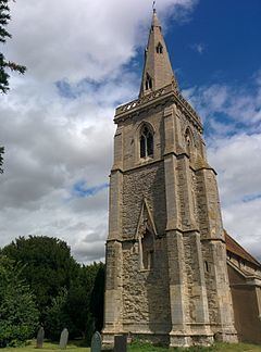
Thoroton and was granted conservation area status in 1974. It is served by St Helena's Church, which is Grade I listed building.
The place name seems to contain an Old Norse personal name Þurferð + tūn (Old English), an enclosure; a farmstead; a village; an estate.., so 'Farm of a man called Thurferth'. There are 19 such place names (Scandinavian personal name followed by tūn ) in Nottinghamshire; all of them in the Domesday survey, and all apparently ancient villages.
Charles Falconer, Baron Falconer of Thoroton takes his name from part of his wife's name and her family home is near Thoroton. The family also owns property in the village, which is let.