
Population 253 (2011 Census) Civil parish Thornton-le-Moors | OS grid reference SJ4474 Dialling code 01244 | |
 | ||
Unitary authority | ||
Bellringing at thornton le moors cheshire
Thornton-le-Moors is a village and civil parish in the unitary authority of Cheshire West and Chester and the ceremonial county of Cheshire, England. At the census of 2001 it had a population of 260, reducing slightly to 253 at the 2011 census.
Contents
- Bellringing at thornton le moors cheshire
- Map of Thornton le Moors Chester UK
- History
- Religious sites
- References
Map of Thornton-le-Moors, Chester, UK
The village is seven miles north east of the city of Chester. It is situated to the south of the A5117 road. To the north of the village is the Stanlow Refinery. To the west is the nearest town of Ellesmere Port and to the north west is the nearest village, Elton
History
Thornton le Moors was a township in Thornton Parish, Eddisbury Hundred, which became a civil parish in 1866.
Religious sites
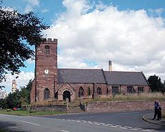
St Mary's Church, Thornton-le-Moors is a Grade I listed building. The church has recently undergone restoration.
References
Thornton-le-Moors Wikipedia(Text) CC BY-SA