
Elevation 2,517 m Topo map USGS Durrwood Creek Parent range Sierra Nevada | Prominence 138 m Mountain range Sierra Nevada | |
 | ||
Similar Sirretta Peak, Olancha Peak, Sawtooth Peak, Owens Peak, Florence Peak | ||
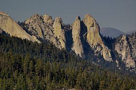
The Needles are a series of massive granite rock formations rising up from the North Fork of the Kern River near its junction with the Little Kern River. The Needles Lookout is located 2.5 miles off the Western Divide Highway (State Route 190) 10 miles north of Mountain Road 50. Johnsondale, California is the nearest town, with the Camp Whitsett, BSA camp around 4 miles from Johnsondale. On July 28, 2011, the Needles lookout, constructed in 1937-1938 by the Civilian Conservation Corps, was destroyed in a structure fire. The lookout tower stood atop the rock formation at 8,245 feet.
Map of The Needles, California 93265, USA
References
The Needles (Sequoia National Forest) Wikipedia(Text) CC BY-SA