Population 292 (2011 census) Postal code 4497 | Postcode(s) 4497 Thallon Daymar Local time Thursday 9:56 PM | |
 | ||
Location 571 km (355 mi) SW of Brisbane407 km (253 mi) SW of Toowoomba189 km (117 mi) SW of Goondiwindi92 km (57 mi) S of St George Weather 19°C, Wind S at 32 km/h, 45% Humidity | ||
Thallon is a town and locality in the Shire of Balonne, Queensland, Australia. At the 2011 census, Thallon and the surrounding area had a population of 382.
Contents
Map of Thallon QLD 4497, Australia
Geography
Thallon is in South West Queensland, 571 kilometres (355 mi) west of the state capital, Brisbane. Thallon is between St George and the border with New South Wales at Mungindi.
History
The town is named after a Queensland Commissioner for Railways, James Forsyth Thallon.
Explorer Thomas Mitchell was the first European in the Thallon district and his initials can still be found on a bloodwood tree near the Moonie River. In 1911, the area was set aside for closer settlement and 780 acres (3.2 km2) were gazetted as a town reserve. With the coming of the railway, the town developed and shops and a hotel were established. Thallon is now a major wheat and woolgrowing area.
Heritage listings
Thallon has the following heritage-listed sites:
Facilities
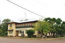
Thallon has a post office, hotel, public library, community hall, showground, park and sportsground. Thallon State School opened on 24 July 1911.
