
Country United States Population 17,745,584 (2,010) | State(s) Texas | |
 | ||
Boston celtics sweep the texas triangle
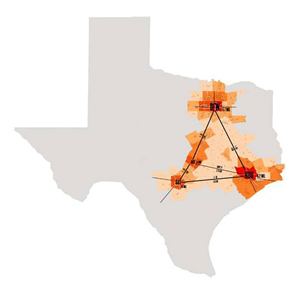
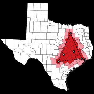
The Texas Triangle is one of eleven megaregions in the United States. These are urban areas that are much greater in scale than a metropolitan statistical area (MSA), defined by the US Census Bureau. These regions also are known as megapolitan areas. The Texas Triangle is formed by the three main cities, Houston, Dallas, and San Antonio, connected by a highway system of Interstate 45, Interstate 10, and Interstate 35. The area is sometime also referred to as the Texaplex.
Contents
- Boston celtics sweep the texas triangle
- Boston celtics completes texas triangle
- Growth
- Definition
- Metropolitan areas
- Micropolitan areas
- Counties Contained in the Triangle
- Texaplex
- The Texaplex Project
- References
Boston celtics completes texas triangle
Growth
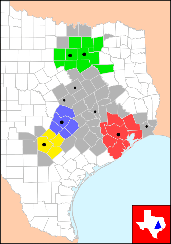
In 2004, the Texas Triangle contained 5 of the 20 biggest cities in the US, and was home to more than 70% of all Texans (pop 13.8 million). In the next 40 years, the population of the Texas Triangle has been projected to grow more than 65%, or an additional ten million people, leading to 78% of Texans living and working within the Texas Triangle. From a resident's perspective, the Triangle is gradually becoming synonymous with Texas.
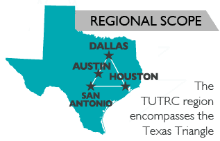
The Triangle is anchored by the metropolitan areas of Houston, Dallas–Fort Worth, and San Antonio. Additional MSAs in the region include Austin, Bryan-College Station, Killeen-Temple-Fort Hood, and Waco. Twelve micropolitan statistical areas are within the Triangle, which includes 66 counties. Beaumont, located east of Houston, has been considered part of the Texas Triangle by numerous studies dating from 2000. Burleson County is the center of the Texas Triangle.
Sizable metro areas in Texas outside the Triangle are Corpus Christi, El Paso, Lubbock, Midland-Odessa, Abilene, San Angelo, Laredo, Amarillo, Tyler, Longview, Wichita Falls and the Rio Grande Valley, which developed according to different histories and geographies.
Definition
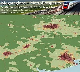
The megaregion is defined in work by "America 2050" and others. Dr. Robert Lang of the Metropolitan Institute at Virginia Tech characterized Dallas–Fort Worth as one of the earliest recognized megapolitans. Although each city is distinct, Dallas and Fort Worth developed closely enough to form the urban area widely known as "The Metroplex." A conference about the future of the Texas Triangle was held by Houston Tomorrow and America 2050 on September 24–25, 2009 in Houston.
The 60,000-square-mile (160,000 km2) region contains most of the state's largest cities and metropolitan areas, and in 2008 had a total of 17 million people, nearly 75 percent of Texas's total population. The region is comparable to Florida in population and comparable to Georgia in area. But, the Texas triangle comprises less than a quarter of Texas's total land area.
According to the University of Texas at Austin Center for Sustainable Development, "the Texas Triangle has three sides measuring 271, 198, and 241 miles in ground distance."
Metropolitan areas
Micropolitan areas
Counties Contained in the Triangle
There are 66 counties within the Texas Triangle. They are as follows: Atascosa, Austin, Bandera, Bastrop, Bell, Bexar, Brazoria, Brazos, Burleson, Caldwell, Chambers, Collin, Colorado, Comal, Cooke, Coryell, Dallas, Delta, Denton, Ellis, Falls, Fayette, Fort Bend, Freestone, Galveston, Gonzales, Grayson, Grimes, Guadalupe, Hardin, Harris, Hays, Henderson, Hill, Hood, Houston, Hunt, Jefferson, Johnson, Kaufman, Kendall, Lavaca, Lee, Leon, Liberty, Limestone, Madison, McLennan, Medina, Milam, Montgomery, Navarro, Orange, Parker, Rockwall, San Jacinto, Somervell, Tarrant, Travis, Walker, Waller, Washington, Wharton, Williamson, Wilson, and Wise
Texaplex
The term "texaplex" was coined by David Winans in 2009. A combination of the terms "Texas" and "metroplex."
The Texaplex Project
The Texaplex Project refers to the online viral video and white paper that was produced by David Winans and MODassic Marketing as a response to the 2008 recession. The short video cites many economic and population statistics in Texas. Facts such as: 4 out of 5 Texans live in the Texaplex - Of all new jobs created in the US, half were in Texas. The video was freely distributed and shared across the web in an effort to counteract the bad economic news with good news.