
Existed: 1919 – present SH 192 SH 193 → Length 62.9 km | SH 196 SH 197 → Constructed 1919 | |
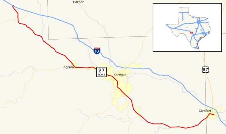 | ||
State Highway 27 is located in Kerr and Kendall counties and runs parallel to Interstate 10.
Contents
Map of TX-27, Texas, USA
History
SH 27 was a route proposed by 1919 to run from San Antonio to Sonora and from Ft. Stockton to just west of Balmorhea, creating a more direct route from San Antonio to El Paso. By 1926, It became one continuous route from San Antonio to Balmorhea. Everything west of Balmorhea became a portion of SH 3. The section from Kerrville to San Antonio was renumbered as SH 81. It was rerouted southeast to Boerne replacing a portion of SH 41. By 1933, it was cosigned with U.S. Highway 290 west of Junction and extended west over a portion of SH 3, which was rerouted. In 1935, the western portion was reassigned northwest from Ft. Stockton, replacing State Highway 192 and the northern portion of SH 17, while the old alignment between Ft. Stockton and west of Balmorhea renumbered as State Highway 196. The new alignment was also codesignated with U.S. Route 285. It also extended southeast to Port Lavaca over portions of SH 81 and SH 29. By 1939, all cosigned sections were removed in favor of their U.S. Highway designations. In 1975, the section from Junction to Mountain Home was removed as it was replaced by I-10.
Route description
SH 27 begins at exit 488 on I-10 in Kerr County north of the town of Mountain Home. The highway heads southeast and east from I-10 to an intersection with SH 41 in Mountain Home. The highway continues to the southeast, generally paralleling to the south of I-10, to an intersection with RM 479. It continues heading southeast until it reaches an intersection with SH 39 in Ingram. From this intersection, SH 27 heads east towards Kerrville. In Kerrville, the highway has intersections with FM 1338 and RM 783 before a junction with SH 16. As the highway leaves Kerrville, it passes by Kerrville Municipal Airport. SH 27 begins to head to the east as it enters Center Point, where it has an intersection with RM 480. The highway continues on to the east with a slight turn to the northeast as it enters Comfort. The highway intersects RM 473 and US 87 in Comfort. It has a short concurrency with US 87 until SH 27 ends at an interchange with I-10 southeast of Comfort.