
Length 55.89 km | North end: FM 439 in Fort Hood | |
 | ||
Existed: by 1939 (current route 1988) – present | ||
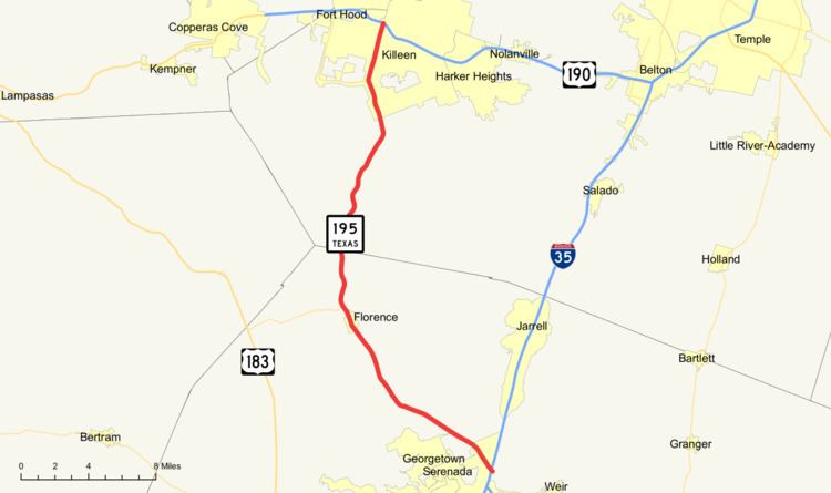
State Highway 195, or SH 195, is a state highway in the U.S. state of Texas that runs from Interstate 35 in Georgetown north to FM 439 in Killeen. In Killeen, SH 195 is known as Fort Hood Street, as the highway leads to the entrance of Fort Hood. The Texas Memorial Highway System has designated the entire road as the Phantom Warriors Highway.
Contents
Map of TX-195, Texas, USA
History
Prior to the 1990s, SH 195 ran from Georgetown and turned approximately one mile (1.6 km) north of Florence, to meet up with U.S. Highway 183. This route was designated by 1933, as a previous portion of SH 36B. The northbound highway to Killeen from Florence was designated as FM 440 in 1951. Today, the entire north–south highway is designated as SH 195. The old east–west portion from Florence to U.S. Highway 183 is now designated as State Highway 138.
As of October 2005, portions of the highway between Killeen and Florence are four lanes with median, or two lanes with shoulders. In Florence, the highway becomes a four-lane road with traffic signals at the intersection of FM 487, as well as the intersection of FM 970, near Florence Middle School and Florence High School. South of FM 970, it is a two-lane road all the way to Interstate 35.
As of October 2005, SH 195 is undergoing a major overhaul. The former two-lane highway is being widened to four lanes with a median and shoulders. The project has been broken up into phases. In the first phase, the road was widened from just south of FM 3470 in Killeen (known locally as Stan Schlueter Loop) to near the intersection with RM 2670 in the community of Ding Dong. The second phase is currently underway, which will add two new bridges over the Lampasas River and will extend to near the Bell-Williamson county line. With an estimated completion date of spring 2016, the third and final phase is also underway. It begins 3 miles south of State Highway 138 near Florence and stretches to Ronald Reagan Boulevard in Georgetown. Due to federally protected bugs which reside in caves under the 195 roads, the progression of the final phase was delayed until funding could be produced to purchase these caves. In the future, new phases will create a divided highway along the entire length of SH 195. It remains to be seen how the new highway will affect the town of Florence. Most likely, a bypass will be constructed around the town, so that travellers can avoid the before-school and after-school traffic in Florence.
There are several reasons for the construction project. The road was once known in Central Texas as the "Highway of Death" due to the many fatal accidents on 195. One small period between 1996 and 1998 saw the loss of 21 lives. The road's new design will ease traffic congestion caused by daily commutes to Georgetown and Austin, since the road is the only route directly to Interstate 35 from Killeen, besides Interstate 14/U.S. Highway 190. Also, the new highway will facilitate vehicle movement in the event of a deployment of troops from Fort Hood en route to Interstate 35.
In addition, the Georgetown terminus of SH 195 is itself being modified, as it is to be the northern terminus of State Highway 130.
On May 31, 2007, the highway officially reopened to the public as the finished divided highway.