
Existed: 1986 – present Length 1.405 km | Constructed 1986 | |
 | ||
North end: Entrance gate to U.S. Coast Guard station | ||
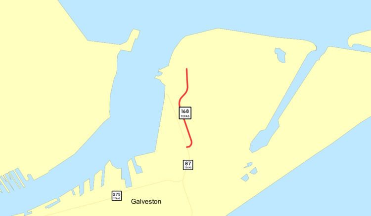
State Highway 168 (SH 168 or TX 168) is a short state highway located entirely within the city of Galveston in the U.S. state of Texas. The highway connects SH 87 to Coast Guard Station Galveston, on the eastern portion of Galveston Island. At just under 0.9 miles (1.4 km) in length, the highway is the second-shortest in the state, and the shortest signed highway (SH165, which is shorter, is officially designated but not signed). The road travels along the edge of residential area for most of its length before it bends northeast and runs through a small marsh.
Contents
Map of TX-168, Galveston, TX 77550, USA
The route was first proposed in 1933; it would have traveled through Atascosia and Wilson counties. Portions of the proposal were replaced by SH 97 by at least 1936, while the rest was cancelled. State Highway 87 first followed the routing of SH 168, but was moved by 1961. A short railroad spur was built along the course of the route, and SH 168 was officially designated in 1986.
Route description
State Highway 168 begins at an at-grade intersection with SH 87, or Ferry Road, on the eastern portion of Galveston Island. The highway runs eastward for a short distance, being bordered by an apartment complex and a small gas station. After bending northward, the road enters rural areas, while following the course of a small, man-made drainage creek. The roadway continues northwest, bordered by marsh and brushland to the east and several resorts and apartment complexes to the west. It bends northeast and proceeds past a small portion of a U.S. Coast Guard station. The route splits away from the creek and continues past Corps Woods Nature Sanctuary, a major birdwatching destination. The highway intersects a small access road to the Coast Guard station, before continuing northward to its northern terminus, the main entrance gate to the Coast Guard facility. A small road continues inside the station from the gate.
The highway is maintained by the Texas Department of Transportation (TxDOT). Part of the TxDOT's job is to measure traffic along the highway. These counts are taken using a metric called annual average daily traffic (AADT), a statistical calculation of the average daily number of vehicles that travel along a portion of the highway. The TxDOT usually measures AADT near an intersection. In 2011, the highway's AADT count was 1500 vehicles, taken at a point just after the intersection with SH 87. This was an increase from the previous year, when the AADT at the same point was approximately 1400 vehicles. This was also an increase from 2009, when the route's AADT was just 1100 vehicles, also taken from the same point. No portion of the roadway is listed on the National Highway System, a network of roads important to the country's economy, defense, and mobility.
History
State Highway 168 was first proposed in 1933, traveling from Campbellton in Atascosia County northeastward to Floresville in Wilson County before bending further eastward and terminating at SH 81. The proposal was listed as a conditional designation, meaning that it would not be maintained by the State Highway Commission. However, by 1935, the portion traveling from Floresville to SH 81, a distance of approximately 11 miles (18 km), was designated as a portion of SH 97, while the rest of the proposed State Highway 168 was cancelled. On September 26, 1939, SH 87 was designated to a road that followed the general course of present-day SH 168.
By 1961, the highway had been shifted westward, but a spur of the Gulf, Colorado and Santa Fe Railroad had been constructed along the approximate location of the highway's present route. On October 24, 1985, SH 168 was approved for designation by the Texas Transportation Commission (TTC), and on April 18, 1986 the highway was officially designated by the TxDOT's Administration Circle. At the time, the road was approximately 0.5 miles (0.80 km) in length. By 1994, the highway had been extended to approximately 0.9 miles (1.4 km) in length, due to an extension of its northern terminus.
Junction list
The entire highway is in Galveston, Galveston County.