
Area 2,093 km² Population 45,418 (2013) | Website www.co.wilson.tx.us Founded 1860 Unemployment rate 3.3% (Apr 2015) | |
 | ||
Marcelina creek ranch for sale in wilson county texas 752 acres
Wilson County is a county located in the U.S. state of Texas. As of the 2010 census, its population was 42,918. Its county seat is Floresville. The county is named after James Charles Wilson.
Contents
- Marcelina creek ranch for sale in wilson county texas 752 acres
- Map of Wilson County TX USA
- Native Americans
- Explorations and county established
- Geography
- Major highways
- Adjacent counties
- Demographics
- Cities
- Towns
- Ghost Towns
- Notable people
- References
Map of Wilson County, TX, USA
Wilson County is part of the San Antonio-New Braunfels, TX Metropolitan Statistical Area.
Native Americans
Archeological evidence in the Wilson County area reveals early habitation from the Paleo-Indians Hunter-gatherers period. Later, the area was a hunting range for Tonkawa, Aranamas, Tamiques, Karankawa. Tawakoni, Lipan Apache and Comanche lived and hunted in the county.
Explorations and county established
In September 1718 Martín de Alarcón crossed the area on his way to explore the bay of Espíritu Santo. Pedro de Rivera y Villalón crossed the county in 1727 as part of an expedition to inspect the frontier defenses of New Spain. In 1766–67 the Marqués de Rubí included the area in his inspection of the Spanish frontier, and the 1798 explorations of the coast by Francisco Vásquez de Coronado skirted the area.
The first two land grants in the area were to Luis Menchaca and Andrés Hernández, who established ranches circa 1832-1833.
Anglos began arriving in the 1840s, and Southern planters in 1850 and 1860, followed by German and Polish immigrants from other counties.
Wilson County was formed in 1860 from Bexar and Karnes. Sutherland Springs was designated the county seat.
Wilson County voted in favor of secession from the Union, and sent several military units to serve. Wartime hardships were compounded by a 3-year drought.
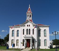
Following the civil war, the county seat was moved to Floresville. The 1872 courthouse was destroyed by fire and replaced in 1884 with a new building designed by Alfred Giles.
Fence Cutting Wars in Texas lasted for approximately five years, 1883-1888. The 40,000-acre (160 km2) ranch of Houston and Dilworth became the focal point in Wilson County. As farmers and ranchers began to compete for precious land and water, cattlemen found it more difficult to feed their herds, prompting cowboys to cut through fences. Texas Governor John Ireland prodded a special assembly to order the fence cutters to cease. In response, the legislature made fence-cutting and pasture-burning crimes punishable with prison time, while at the same time regulating fencing. The practice abated with sporadic incidents of related violence 1888.
The San Antonio and Aransas Pass Railway reached Floresville in 1886. In 1898 the San Antonio and Gulf Railroad was extended to Stockdale.
Geography
According to the U.S. Census Bureau, the county has a total area of 808 square miles (2,090 km2), of which 804 square miles (2,080 km2) is land and 4.7 square miles (12 km2) (0.6%) is water.
Major highways
Adjacent counties
Demographics
As of the census of 2000, there were 32,408 people, 11,038 households, and 8,830 families residing in the county. The population density was 40 people per square mile (16/km²). There were 12,110 housing units at an average density of 15 per square mile (6/km²). The racial makeup of the county was 36.45% White, 1.21% Black or African American, 0.58% Native American, 0.30% Asian, 0.04% Pacific Islander, 14.25% from other races, and 2.43% from two or more races. 44.74% of the population were Hispanic or Latino of any race.
There were 11,038 households out of which 40.00% had children under the age of 18 living with them, 66.50% were married couples living together, 9.20% had a female householder with no husband present, and 20.00% were non-families. 17.10% of all households were made up of individuals and 7.80% had someone living alone who was 65 years of age or older. The average household size was 2.89 and the average family size was 3.26.
In the county, the population was spread out with 29.20% under the age of 18, 7.60% from 18 to 24, 28.60% from 25 to 44, 23.20% from 45 to 64, and 11.50% who were 65 years of age or older. The median age was 36 years. For every 100 females there were 99.70 males. For every 100 females age 18 and over, there were 97.00 males.
The median income for a household in the county was $40,006, and the median income for a family was $45,681. Males had a median income of $31,716 versus $23,582 for females. The per capita income for the county was $17,253. About 9.20% of families and 11.30% of the population were below the poverty line, including 12.40% of those under age 18 and 15.80% of those age 65 or over.