
 | ||
Terrenate (formally: San Nicolás Terrenate) is a city, and the surrounding municipality of the same name, in the Mexican state of Tlaxcala. It is situated in the highest part of the state, at 2,680 metres above sea level. "Terrenate" is a Nahuatl name meaning "land the colour of masa" (maize dough).
Contents
Map of Terrenate, Tlaxcala, Mexico
Location
Terrenate is in the extreme northeast of the state, adjacent to the municipalities of:
to the west, Tetla de la Solidaridad, Emiliano Zapata, and Lázaro Cárdenasto the south, Huamantla and Xaloztocto the east, Altzayancato the north, Ixtacamaxtitlán in the neighbouring state of Puebla.Economy
Chiefly agricultural: crops and livestock. Little other industry or employment opportunities. Migration levels, particularly to the United States, are high.
Towns
In 1996, what are now the municipalities of Emiliano Zapata and Lázaro Cárdenas, were split off from Terrenate when the state created 16 new municipalities.
In addition to the municipal seat, the municipality has another six towns and numerous hamlets.
Culture
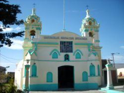
The church of San Nicolás de Tolentino in the municipal seat dates from the 17th century.