
Location Caribbean sea Total islands 9 Area 5.2 km (2.0 sq mi) Elevation 306 m City Fond-du-Curé, les Saintes | Archipelago Îles des Saintes Highest elevation 306 m (1,004 ft) Capital Fond-du-Curé, les Saintes | |
 | ||
Island groups Îles des Saintes, Antilles, Lesser Antilles, Leeward Islands Points of interest Leeward Islands, Fort Napoléon des Saint, Pain de sucre, Chameau, Musée Du Fort Napoleon | ||
Terre-de-Haut Island (officially in French :Terre-de-Haut des Saintes (literally: highland of les Saintes)) is an island in the Îles des Saintes archipelago, in the Lesser Antilles. It belongs to the commune (municipality) of Terre-de-Haut into the French department of Guadeloupe.
Contents
Map of Terre-de-Haut, Guadeloupe
Description
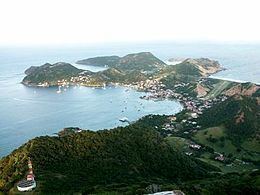
Terre-de-Haut island is the most easterly island of the archipelago of les Saintes. Like its neighbour Terre-de-Bas, it holds its name from the maritime vocabulary which called the islands exposed to the wind highland and those protected from the wind, lowlands. It is an island of 5.2 km2 (2.0 sq mi) dominated in the north by Morne Mire hill (107 metres (351 ft)) and Morel hill (136 metres (446 ft)) and in the South by Chameau hill 306 metres (1,004 ft), the highest mount of the island and the entire archipelago. Terre-de-Haut is separated from Terre-de-Bas by a narrow channel of 890 m (0.55 mi). Besides Terre-de-Bas, several small islands surround Terre-de-Haut:
The Pain de sucre peninsula, with the height of (53 metres (174 ft)) is linked to Terre-de-Haut by an isthmus.
Populated areas
Small villages are seen spread out in the rolling hills in the interior. Fond-du-Curé is located in a natural harbour. Yachts and cruise boats are a common sight in the harbour. The oldest settlements still remaining are the villages of Mouillage and Fond-du curé. The population is spread among 20 quartiers (districts), more or less well delimited. They are grouped into two halves:
The local vocabulary says: "to go up" to move towards the windward quartier (to Fort Napoléon) and "to go down" to move towards the leeward quartier (to Pain-de-sucre).
Demography
The inhospitable relief and the low precipitation do not allow the establishment of agriculture. Few slaves were brought onto these islands. The population is constituted historically by Bretons, Normans and by inhabitants of Poitou who settled down to fish. This explains the European type of the people from les Saintes (Saintois) French: [sɛ̃twa] (French gentilic of the inhabitants of les Saintes).
In 2006 the population of Terre-de-Haut was 1,838, with a density of population of 306 inhabitants/km2. The number of households was 693.
Economy
The island lives essentially on fishing and tourism. The island contains a UCPA center with 60 bungalows, and receives approximately 120 trainees every week. it closes for two months every year because of the weather conditions.