
Owned by WMATA Structure type Underground Bicycle facilities 20 Tracks 2 | Opened 25 August 1984 Platforms in use 1 | |
 | ||
Parking 17 spaces (parking meters) Address Washington, DC 20016, United States Similar Van Ness–UDC station, Friendship Heights station, Brookland–CUA station, NoMa–Gallaudet U station, Cleveland Park station | ||
Tenleytown–AU is a rapid transit station on the Red Line of the Washington Metro in Washington, D.C. Located in the Upper Northwest neighborhood, it is the last station on the Red Line heading outbound wholly within the District of Columbia; the next stop, Friendship Heights, lies within both the District and the state of Maryland.
Contents
Location
The southernmost station underneath the Wisconsin Avenue NW corridor, Tenleytown–AU station lies within the neighborhood of the same name in the Upper Northwest portion of the city. More specifically, it lies north of Tenley Circle, for which the area is named, below Wisconsin Avenue NW at its intersection with Albemarle Street NW. Nearby are several educational institutions, the most notable of which are: American University (AU, which is over one mile away from the station, albeit connected by a shuttle); Sidwell Friends School (famous for being the school of choice of presidential children); Woodrow Wilson High School; the high school of Georgetown Day School; and the affiliated National Cathedral School and St Albans Schools. In addition, Fort Reno Park and the Washington National Cathedral are located close to the station.
History
Originally to be called Tenley Circle, in February 1980 the Metro Board officially changed its name to Tenleytown. The station opened on August 25, 1984. Its opening coincided with the completion of 6.8 miles (10.9 km) of rail northwest of the Van Ness–UDC station and the opening of the Bethesda, Friendship Heights, Grosvenor and Medical Center stations. In May 1989, although objected to by several community groups, the Metro Board officially changed its name to Tenleytown–AU due to its proximity to American University. The $63,500 cost of changing the names on signs, pylons and maps throughout the system was paid for by the District government.
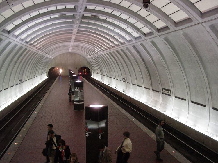
Station layout
Like most underground stations on the northwestern stretch of the Red Line, Tenleytown–AU has three levels below street level: a middle landing, mezzanine, and the platform. There are two entrances, one on either side of Wisconsin Avenue NW, that lead to a middle landing below the avenue. A set of escalators brings passengers from the landing to the mezzanine, the location of fare control. A final group of escalators links the mezzanine with the single island platform, characteristic of deep-bore stations on the Washington Metro. Uniquely, due to architectural and structural reasons, there is an elevator directly to the platform, with a faregate at that level.