
- elevation 49 ft (15 m) | - elevation 0 ft (0 m) | |
 | ||
- right North Fork Ten Mile Creek | ||
Ten Mile River is a river in northern Mendocino County, California, United States. It is named for the fact that its mouth is 10 miles (16 km) north of the mouth of the Noyo River. The middle and north forks of the river are each 15 miles (24 km) long, and the river extends for seven more miles from their confluence to its mouth, on the Pacific Ocean. The watershed of Ten Mile River is neighbored on the south by the Noyo River and on the east and north by the South Fork Eel River. 75 acres (30 ha) of salt marsh provide a habitat for many birds. Ten Mile Beach, in MacKerricher State Park, extends approximately five miles southward from the mouth of the river to Cleone, including approximately 1,300 acres (530 ha) of what has been called California's "most pristine stretch of sand dunes."
Contents
Map of Ten Mile River, California, USA
HistoryEdit
The Ten Mile River basin has been logged continuously since the early 1870s. At first, trees were cut using single-bladed axes and dragged by oxen to mills at Fort Bragg, ten miles to the south. Railroad lines were introduced on the South Fork in 1910 and on the other parts of the river in the 1920s. In the 1930s, the railroads were replaced by tractor roads; after the passage of the California Forest Practice Act in 1973, tractor logging on steeper slopes was supplanted by more environmentally friendly practices such as the use of cables. The timber on both sides of the river was logged by the Georgia Pacific Company until 1999, when Georgia-Pacific's holdings in the area were acquired by the Hawthorne Timber Company. Timber in the area is logged on a 60-year rotation.
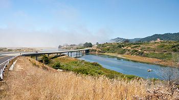
An 1861 story in Harper's Monthly includes a passage recounting the crossing of Ten Mile River: "We found the crossing a little dangerous on account of the tide, which sometimes renders it impassable for several hours, except by swimming. With some plunging, spurring, and kicking, the opposite side was gained in due time". Later, the river was spanned near its mouth by a bridge on California State Route 1, north of the community of Inglenook. A concrete beam bridge replaced an older wooden deck truss bridge in 1954. After studies found that the 1954 bridge was insufficiently earthquake-safe, a new concrete box girder bridge on Highway 1 was constructed in 2009. The new bridge is 45 feet (14 m) wide and 1,479 feet (451 m) long; it cost $43.5 million to construct.
EcologyEdit
The river is used for navigation, recreation, and municipal, agricultural, and industrial water supply. The river also provides groundwater recharge and wildlife habitat including cold freshwater habitat for fish migration and spawning. As with many rivers in the area, the Ten Mile River is subject to environmental problems caused by logging. A United States Environmental Protection Agency study reported that "Sediment was determined to be impacting the cold water fishery, a beneficial use of the Ten Mile River watershed, including the migration, spawning, reproduction, and early development of cold water fish such as coho salmon and steelhead trout. Cold freshwater and estuarine habitats are also designated beneficial uses of the Ten Mile River watershed." The spawning population of coho salmon in Ten Mile River has been observed to decrease from an estimate of 6000 fish in the early 1960s to much lower numbers ranging from 14 to 250 in the 1990s. Factors that have been advanced to cause this decline include natural variability, excessive sedimentation from logging, increased water temperatures due to the removal of shade trees and increased airflow over riparian areas, and lessened amounts of woody debris in salmon habitats.
The endangered Tidewater goby (Eucyclogobius newberryi) is also found in the creek's brackish coastal lagoon and several miles upstream in sections of stream impounded by California Golden beavers (Castor canadensis subauratus) which provide ideal slow-moving water habitat for gobies.
WatershedEdit
The Ten Mile River mainstem begins at the confluence of North Fork Ten Mile River and Middle Fork Ten Mile River, flows southwest then northwest to the Pacific Ocean 5.7 miles (9.2 km) south of Westport. The North Fork Ten Mile River begins at elevation 2,400 feet (730 m). The Middle Fork Ten Mile River begins at elevation 2,460 feet (750 m) on the north side of Sherwood Peak.