
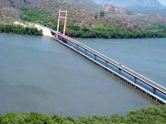
Length 144 km Mouth Gulf of Nicoya | Basin area 611 km² Bridges Taiwan Friendship Bridge | |
 | ||
Cities Palo Verde Biological Station | ||
Discover costa rica vacation trip day 5 crocodile at tempisque river
The Tempisque River, or Río Tempisque, is 144 km long, located entirely in Costa Rica flowing from the Guanacaste Cordillera near the Orosí Volcano and emptying into the Gulf of Nicoya. It passes through the Palo Verde National Park and is an important habitat for various species of crocodiles, monkeys, iguanas and birds.
Contents
- Discover costa rica vacation trip day 5 crocodile at tempisque river
- Map of Rio Tempisque Costa Rica
- Costa rica playa flamingo tempisque river and arenal part 1
- References
Map of Rio Tempisque, Costa Rica
The river is heavily silted, limiting navigation to shallow crafts that can cross the muddy flats. Tidal conditions dictate the timing to cross the bar at the river mouth.
Historically the Tempisque was used to float logs down to the sea. The logs were gathered at Chira Island to be loaded on ships.
The Tempisque River Bridge was built linking the Nicoya Peninsula to southern Guanacaste and hence significantly cut travel time to San José. It was funded by a gift from the Taiwanese government, and opened in November 2002.