
 | ||
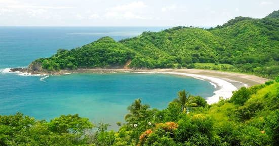
Montezuma costa rica nicoya peninsula
The Nicoya Peninsula (Spanish: Península de Nicoya) is a peninsula on the Pacific coast of Costa Rica. It is divided into two provinces: Guanacaste Province in the north, and the Puntarenas Province in the south. It is located at 10°N 85.4166667°W / 10; -85.4166667. It varies from 19 to 37 miles (60 km) wide and is approximately 75 miles (121 km) long, forming the largest peninsula in the country. It is known for its beaches and is a popular tourist destination.
Contents
- Montezuma costa rica nicoya peninsula
- Map of Nicoya Peninsula Costa Rica
- Tambor bay getting there nicoya peninsula costa rica
- Places of interest
- Conservation
- Notable features
- References
Map of Nicoya Peninsula, Costa Rica
The main transport and commercial centre in the region is Nicoya, one of the oldest settlements in Costa Rica. Ferries run between the town of Puntarenas on the mainland and the Nicoya Peninsula. There is an international airport in Liberia and small domestic airstrips in Nosara, Carrillo and Tambor. The region was also featured in the book Blue Zones, by Dan Buettner, which focused on the longevity found among Nicoya's residents.
Tambor bay getting there nicoya peninsula costa rica
Places of interest
Other notable settlements and places of interest in the area include (going roughly from north to south): Tamarindo, Santa Cruz, Nosara, Sámara, Naranjo, Paquera, Curu, Tambor, Montezuma, Santa Teresa, Mal Pais.
Conservation
There are a number of nature reserves and wildlife refuges such as Cabo Blanco, Camaronal, Cueva Murciélago, Curú, La Ceiba, Romelia and the Diria National Park, as well as the projects on the islands of the adjacent Gulf of Nicoya.
Notable features
The Nicoya Peninsula is considered by Quest Network one of the Blue Zones in the world, where people commonly live active lives past the age of 100 years.