
- elevation 4,200 ft (1,280 m) Length 85 km | - elevation 814 ft (248 m) Basin area 738.1 km² | |
 | ||
- average 284 cu ft/s (8 m/s) (mean for water years 1926-1981) - max 21,500 cu ft/s (609 m/s) May 1840 Mouths Tellico Reservoir, Little Tennessee River | ||
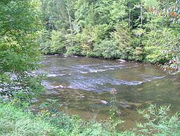
Tellico river bald river falls tellico plains tn
The Tellico River rises in the westernmost mountains of the U.S. state of North Carolina, but it flows mainly through Monroe County, Tennessee. With a length of 52.8 miles (85.0 km), it is a major tributary of the Little Tennessee River, and is one of the primary streams draining the Unicoi Mountains.
Contents
- Tellico river bald river falls tellico plains tn
- Map of Tellico River Vonore TN USA
- The laborn fishing show tellico river trout
- HydrographyEdit
- HistoryEdit
- EtymologyEdit
- References
Map of Tellico River, Vonore, TN, USA
The Tellico River and its main tributaries are renowned for their brook, brown, and rainbow trout fishing. Upstream from Tellico Lake, above Tellico Plains, Tennessee, the Tellico is a premier trout stream. It meanders through a mountain gorge before reaching the broad plains downstream of Tellico Plains.
The laborn fishing show tellico river trout
HydrographyEdit
The Tellico River rises in the Unicoi Mountains (a subrange of the Blue Ridge Mountains) near the Cherokee County/Graham County line, in North Carolina's Nantahala National Forest. The North Carolina side includes the Upper Tellico Off-highway vehicle area.
After the river crosses into Tennessee and enters the Cherokee National Forest, it is joined by its major tributaries, the Bald and North rivers. After exiting the mountains, the river enters Tellico Plains, a relatively flat and isolated area carved out by the river and several tributaries, namely Morgan Creek and Smoky Run. A 4-mile (6.4 km) stretch of the river above Tellico Plains runs parallel to the Cherohala Skyway.
Beyond Tellico Plains, the river winds its way northward through rural Monroe County, Tennessee, before entering the slack waters of Tellico Lake. This lower section of the river absorbs several major streams, including Ballplay Creek and Notchy Creek. Fort Loudoun, a reconstructed 18th-century fort that is now the focus of a state park, stands on an island at the Tellico River's confluence with the Little Tennessee River.
HistoryEdit
The Tellico River basin was logged by the Babcock Lumber Company in the early 20th century. The present-day road up the Tellico River from Tellico Plains was built on the old Babcock logging railroad bed. After the Tellico River basin forests were cut, Babock sold the land to the United States Forest Service.
The Tellico River's rocky descent provides class III-IV whitewater recreation. The runs are especially popular during the spring because of higher water levels. The narrow extreme rapids on the Tellico River are well suited for kayaks, canoes - C1's and duckies, but not for larger rafts. There is continuous access to the river from the road, but these runs are popular:
EtymologyEdit
According to the United States Geological Survey, variant names of the Tellico River include Delaquay River, Talequo River, Terrique River, and Tellequo River.
The word "Tellico" was the name of several Cherokee towns, the largest of which was Great Tellico, located on the Tellico River near present-day Tellico Plains, Tennessee. In Cherokee the word is more properly written "Talikwa". According to James Mooney, the Cherokee meaning of the word was lost. The origin of the word is believed to be Muskogee (Creek). A Muskogean town named Taliko was thriving on the Tellico River when Spanish explorers visited in area in the mid-16th century. Taliko means "bean" in Muskogee.