
Population 942 (2006) | Region Waikato Local time Tuesday 9:14 AM | |
 | ||
Weather 19°C, Wind E at 11 km/h, 93% Humidity | ||
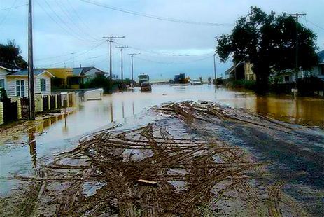
Te Puru is a locality on the western side of the Coromandel Peninsula of New Zealand. State Highway 25 runs through it. Tapu lies about 7 km to the north, and Thames is about 12 km to the south. The Te Puru Stream and about 18 tributaries drain a steep hilly 23 km² area of the Coromandel Range, almost entirely covered by native forest. It runs through the settlement and into the Firth of Thames to the west. Flooding has been a problem.
Contents
Map of Te Puru 3575, New Zealand
The population for Te Puru and Thornton Bay to the south was 942 in the 2006 Census, a decrease of 12 from 2001.
Education
Te Puru School is a coeducational full primary (years 1-8) school with a decile rating of 6 and a roll of 162.
History
Te Puru suffered severe flooding during the 'weather bomb 2002'. The weather bomb was a low-pressure system that led to extensive flooding on the Coromandel Peninsula and the south-west Waikato region. Te Puru and Waiomu were included in the ‘high impact’ area of the storm. Private and public property was damaged during the flood.