
Prominence 2,344 m (7,690 ft) Elevation 2,404 m Easiest route Hiking | Listing Ultra-prominent peak | |
 | ||
Similar Parnon, Voidokilia beach, Costa Navarino, Aroania, Pindus | ||
Mount taygetus the pyramid
The Taygetus, Taugetus, Taygetos, or Taÿgetus (Greek: Ταΰγετος, Taygetos), is a mountain range in the Peloponnese peninsula in Southern Greece. The highest mountain of the range is Mount Taygetus, also known as the "Profitis Ilias", or "Prophet Elias". The name is one of the oldest recorded in Europe, appearing in the Odyssey. In classical mythology, it was associated with the nymph Taygete. During Byzantine times and up until the 19th century, the mountain was also known as Pentadaktylos (Πενταδάκτυλος; Greek for five-fingered, a common name during that period).
Contents
- Mount taygetus the pyramid
- Map of Taygetus Farida 230 54 Greece
- Caviar of love fishing in taygetus mountain giannis gerontidis tedxsparta
- Physical
- Political
- Geology
- Ecology
- History
- Religion
- Recreation
- References
Map of Taygetus, Farida 230 54, Greece
Caviar of love fishing in taygetus mountain giannis gerontidis tedxsparta
Physical
The Taygetus Massif is about 100 km (62 mi) long, extending from the center of the Peloponnese to Cape Matapan, its southernmost extremity. It contains the tallest mountain in the Peloponnese, the Profitis Ilias summit, reaching 2,404 m (7,887 ft); this is probably the classical Mount Taléton mentioned by Pausanias. The summit is an ultra prominent peak. It is prominent above the Isthmus of Corinth, which separating the Peloponnese from mainland Greece, rises only to approximately 60 m (200 ft). Numerous creeks wash down from the mountains and the Evrotas river has some of its headwaters in the northern part of the range. The western side of the massif houses the headwaters of the Viros gorge, which carries winter snowmelt down the mountain, emptying into the Messenian Gulf in the town of Kardamili.
Political
Taygetus overlooks the cities of Sparta and Kalamata, whose skyline it dominates. The mountain range lies within the prefectures of Arcadia, Laconia and Messenia. Taygetus is crossed by Greek National Road 82, which links Kalamata to Sparta and separates Northern Taygetus from the Central Range. The Rindomo Gorge separates the Central Range from Southern Taygetos. The section of Taygetus that forms the backbone of the Mani Peninsula is also known as Saggias, and is often not considered part of Taygetus. The central part of the mountain range is commonly called "Skoteini Plevra", which means "the dark side" because the villages located there do not receive as much sunshine in the early morning and the late afternoon hours.
Geology
The mountains of southern Europe that fringe the Mediterranean Sea and run generally in an east-west direction are of the folded type generated by collision of the northward-moving African Plate with the Eurasian Plate. Where the northern edge of the African Plate is being subducted in an irregular line a second orogeny occurs that is not entirely understood. The mountains of Italy and Greece are a combination of Folded Mountains and Fault-block mountains running in a northwest-southeast direction.
The Hellenic Subduction carries the leading edge of the African Plate under the Aegean Sea Plate at the Hellenic Trench. It follows an arc around the outer edge of the Peloponnese and Crete. The subduction on the west is to the northeast, on the east to the northwest, and north in the center. The average direction is N 21° E. In the islands and southern Greece a fault-block mountain orogeny prevails due to a double set of crustal movements. On the one hand the Aegean Sea Plate is being raised by the subduction. On the other hand, north-south extensional movements, yet unexplained, are pulling the plate apart, creating normal extensional faults and generating a parallel sequence of horsts and grabens, or rift valleys, running in a north-south direction.
Mount Taygetus is a limestone horst bordering the Eurotas Rift Valley. Below its eastern face is the Sparta fault, a normal fault striking perpendicular to the direction of extension. Footwall scarps are visible on the eastern side of Taygetus at the base of its spurs. They result from sudden slippages of the hanging wall in the direction of the dip, causing earthquakes. Single earthquakes result in 1–12 m of scarp. The Sparta fault is zig-zag in strike, varying between N 170° E and N 140° E. The maximum slippage has been 10–12 m in three increments. The earthquake of 464 BC, which levelled Sparta, resulted from a slippage of 3–4 m over a length of 20 km of the fault. The slip rate has been about 1 mm per year suggesting an average interval between earthquakes of 3000 years.
Ecology
The slopes of Taygetus are heavily forested, primarily with Greek fir (Abies cephallonica) and black pine (Pinus nigra). Devastating fires in 2005 and 2007 consumed much of the forests on the central west slopes, and only about half remain.
History
The slopes of Taygetus have been inhabited since at least Mycenean times. The site of Arkina, near the village of Arna, contains three beehive tombs and is still unexplored. Taygetus was important as one of Sparta's natural defenses. The Spartans threw criminals and "unfit" (weak, sickly, deformed, or mentally retarded) infants into a chasm of Taygetus known as Ceadas or Caeadas (Greek: Καιάδας). In antiquity, Spartan newborns were abandoned there if deemed unfit after examination for vitality. Recent evidence, found by the University of Athens, discovered remains of adult individuals which appeared to confirm that Ceadas was mainly a place of punishment for criminals, traitors and captives. During the era of barbarian invasions, Taygetus served as a shelter for the native population. Many of the villages in its slopes date from this period. In Medieval times, the citadel and monastery of Mystras was built on the steep slopes, and became a center of Byzantine civilizations and served as the capital of the Despotate of the Morea. Mystras remains occupied by a tiny religious community. The buildings are remarkably well-preserved and a major tourist attraction in the region. It is a UNESCO World Heritage Site.
Religion
The peak known as Taleton, above Bryseae, was 'dedicated' to Helios, the Sun, to whom horses were sacrificed. Taleton was also 'dedicated' to Zeus. Today, the mountain is closely associated with the holy Prophet Elias, and every year on the 20th of July (the Greek Orthodox name day for the Prophet Elias), the small chapel at the peak holds a large festival, including a massive bonfire in commemoration of the Prophet Elias (note: a Greek-style transliteration of 'Eliyah,' אליה the prophet), as he is believed to have ascended up into heaven in a chariot of fire. The bonfire can be seen from anywhere with clear view of the summit, and it is for this reason that the town of Kardamyli is a local gathering point for those who wish to view the fire without having to climb the mountain.
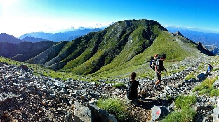
Recreation
The mountain is a popular hiking destination and is part of the European walking route E4. The view from the top includes most of the Evrotas valley and the Parnon range to the east, while the view towards the west includes Kalamata and the eastern half of Messenia. Most of the southwestern part of Arcadia can also be seen from the summit.