
Elevation 1,240 m (4,070 ft) Area 45.8 km² Postal code 39020 Dialling code 0473 | Time zone CET (UTC+1) Local time Monday 1:27 PM | |
 | ||
Frazioni Pundweil (Pontevilla), Rifair (Rivaira) Weather 12°C, Wind SE at 8 km/h, 33% Humidity Region Trentino-Alto Adige/South Tyrol | ||
Taufers im m nstertal
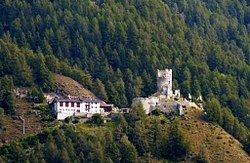
Taufers im Münstertal ( [ˈtaʊ̯fɐs ɪm ˈmʏnstɐtaˑl]; Italian: Tubre [ˈtuːbre]; Romansh: Tuer) is a comune (municipality) in South Tyrol in northern Italy, located about 70 kilometres (43 mi) west of the city of Bolzano, on the border with Switzerland.
Contents
- Taufers im m nstertal
- Map of 39020 Tubre Province of Bolzano South Tyrol Italy
- 360 3 m rz 2015 taufers im m nstertal
- Geography
- Frazioni
- Coat of arms
- Linguistic distribution
- References
Map of 39020 Tubre Province of Bolzano - South Tyrol, Italy
360 3 m rz 2015 taufers im m nstertal
Geography
As of November 30, 2010, it had a population of 964 and an area of 45.8 square kilometres (17.7 sq mi).
Taufers borders the following municipalities: Glurns, Mals, Prad am Stilfser Joch, Stilfs, Lü (Switzerland), Müstair (Switzerland), Santa Maria Val Müstair (Switzerland), Scuol (Switzerland), and Valchava (Switzerland).
Frazioni
The municipality of Taufers contains the frazioni (subdivisions, mainly villages and hamlets) Pundweil (Pontevilla) and Rifair (Rivaira).
Coat-of-arms
The shield is party per bend, the first part of gules and the second fusilly of argent and azure. It is the insignia of Lords of Reichenberg who lived in the local castle since 1373. The emblem was granted in 1967.
Linguistic distribution
According to the 2011 census, 97.85% of the population speak German and 2.15% Italian as first language.