
Comarca Eo-Navia Demonym(s) tapiego Elevation 645 m Population 3,929 (2014) Local time Sunday 9:26 PM | Capital Tapia Time zone CET (UTC+1) Area 65.99 km² | |
 | ||
Weather 12°C, Wind E at 5 km/h, 77% Humidity Points of interest Faro Isla De Tapia, Playa de Ribeiría, Playa de Represas, Mirador Os Cañois | ||
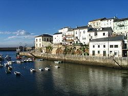
Tapia de Casariego (Eonavian: Tapia) is a municipality in the Autonomous Community of the Principality of Asturias, Spain. It is bordered on the north by the Cantabrian Sea, on the east by El Franco, on the south and west by Castropol. Tapia is also the name of one of the parishes inside the municipality. Its capital is Tapia. The capital, is 127from Oviedo, from Gijón 122 km, 97 km from Lugo, from these cities can reach the council via road N-634, the freeway A-8 (E70), and Ranon the airport in site 86 km from the town, another railroad access is by the railway line FEVE Ferrol - Gijón with stops in La Roda.
Contents
Map of Tapia de Casariego, Asturias, Spain
Geography
The council is divided into parishes, formed in turn by places or neighborhoods (small groups of widely scattered houses) throughout the territory. This is due to land ownership typical in the Autonomous Community: smallholder highly fragmented into small parcels. The terrain is gentle enough altitudes into the interior of the municipality are the most noteworthy pointing the Grandela (348 m) and the hill of Posadoiro (600 m). The Council has diverse beaches among which are found, the Penarronda (shared with the council in Castropol), Santa Gadea, Serantes, Los Campos, Porcía (Shared with the council of El Franco).
History
The council was established in 1863 when several parishes of the councils of Castropol (3) and El Franco (1) separated. The main driving force behind the creation of the new council was Fernando Fernández de Casariego, Marquis de Casariego. In recognition and appreciation, the Tapia council completed its name as 'Tapia de Casariego'.
In the 10th century the king Ramiro II, donate to the Bishop of Oviedo the territory between the Eo river and Navia and that is including the current council Tapia de Casariego. This grant is ratified by King Alfonso VII in the 12th century, which confirms that the territory Oviedo is the Obispalia in strong conflict with that of Lugo Salave retaining possessions and Villamil.
Economy
Currently, the primary sector remains the greatest number of jobs generated, with just over 41% of the total. While agriculture, livestock and fisheries are in a slow decline in the tertiary sector.
The secondary sector is the least influence on the town, representing 18% of local jobs. The construction industry is one that generates more jobs, with some also representing the food industry and processing of metals.
The tertiary sector represents about 41% of the local economy becoming more and more weight on it thanks to tourist activity that occurs in the area. being the hotel which carry the greatest number of jobs.