
Construction began 1958 Height 45 m Catchment area 460 km² | Status Operational Opening date 1960 Length 216 m Inflow source Murrumbidgee River | |
 | ||
Similar Murrumbidgee River, Geehi Dam, Jindabyne Dam, Tumut Pond Dam, Blowering Dam | ||
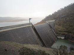
Tantangara Dam is a major ungated concrete gravity dam with concrete chute spillway across the Murrumbidgee River upstream of Adaminaby in the Snowy Mountains region of New South Wales, Australia. The dam is part of the Snowy Mountains Scheme, a vast hydroelectricity and irrigation complex constructed in south-east Australia between 1949 and 1974 and now run by Snowy Hydro. The purpose of the dam includes water management and conservation, with much of the impounded headwaters diverted to Lake Eucumbene. The impounded reservoir is called Tantangara Reservoir.
Contents
- Map of Tantangara Reservoir New South Wales Australia
- Location and features
- Water flows
- Recreation
- References
Map of Tantangara Reservoir, New South Wales, Australia
Location and features
Commenced in 1958 and completed in 1960, the Tantangara Dam is located on the Murrumbidgee River, approximately 6 kilometres (3.7 mi) downstream of its confluence with Gurrangorambla Creek and is wholly within the Kosciuszko National Park. Her Royal Highness Princess Alexandra of Kent visited the dam in 1959, during its construction.
The dam was constructed by Utah-Brown & Root Sudamericana on behalf of the Snowy Mountains Hydro-Electric Authority, and is now managed by Snowy Hydro Limited. The concrete gravity dam of 73,800 cubic metres (2,610,000 cu ft) is 45 metres (148 ft) high with a crest length of 216 metres (709 ft). At 100% capacity, the dam wall holds back 254,099 megalitres (8,973.4×10^6 cu ft) of water. The surface area of Tantangara Reservoir is 2,117.7 hectares (5,233 acres) and the catchment area is 460 square kilometres (180 sq mi). The spillway across the Murrumbidgee River is capable of discharging 900 cubic metres per second (32,000 cu ft/s).
Diverted water flows from Tantangara Reservoir are also pumped to Lake Eucumbene via the Murrumbidgee Eucumbene Haupt-tunnel; comprising two 2.13 metres (7 ft 0 in) by 3.05 metres (10.0 ft) high shafts, from the outlet works tower and tapering to 2.13 metres (7 ft 0 in) diameter before passing through a 1.50 metres (4 ft 11 in) diameter nozzle to river diversion tunnel, with a capacity of 70.8 cubic metres per second (2,500 cu ft/s).
Water flows
In 2005, the Australian Capital Territory Government explored the options of augmenting water supply for Canberra by developing a long tunnel alternative including weir, connecting tunnel, outflow pipes, and hydro-power plant construction to link the Murrumbidgee with Corin Reservoir; and/or a Murrumbidgee River flow alternative including weir, pumping station and pipeline construction to link the Murrumbidgee with Googong Reservoir. In 2009, the ACT Government endorsed a recommendation from ACTEW for implementation of the Tantangara Transfer Project, that involves transferring water from the Murrumbidgee River (below the Burrinjuck and Blowering dams) in New South Wales to the ACT via the Snowy Mountains Scheme.
A 2011 report by the Snowy Scientific Committee stated that the Tantangara Dam was starving the upper Murrumbidgee River of environmental water flows from the Snowy Mountains; needed to restore river health. The committee claimed that there was an apparent "administrative and managerial void", with no river management strategy and no proper monitoring because of a lack of regulatory resources.
Recreation
Despite very low water levels in the Tantangara Dam for a number of years, there are good populations of both brown trout and rainbow trout within the reservoir.