
Easiest route Paved road Prominence 126 m | Elevation 614 m | |
 | ||
Age of rock Greater than 10,000 years Similar Diamond Head, Koʻolau Range, Olomana, Mount Tantalus, Ka'ala | ||
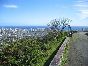
Mount Tantalus (Puu-ohia), is an extinct cinder cone in the southern Koʻolau Range on the Hawaiian Island of Oʻahu. It also has a summit crater, Tantalus Crater. The cinder cone formed after the demise of Koʻolau Volcano, during a time of rejuvenated stage volcanism in southeastern Oʻahu that also formed Punchbowl Crater, Diamond Head and Koko Head. Tantalus overlooks the modern city of Honolulu, which is built on top of Tantalus cinders.
Contents
Map of Tantalus, Honolulu, HI 96813, USA
History
The six-mile Tantalus Loop was a popular wagon trail from the late 1800s for views and picnic parties. It had "rugged canyons, wooded valleys, aromatic eucalyptus giants, stag-horn fern, pungent guava", monkeypod, shower cassias, and myrtle, with a two-room, corrugated-roofed "Half-Way House", managed by 1900's forester David Haugh, offering a welcome stop for trekkers. Many immigrant families of note settled there "in cool picturesque seclusion", including Waterhouses, Giffords, Wilders, Dickeys, Davies, Isenbergs, Browns, and Alexanders. A 25-foot cliff of pitch-black volcanic sand was an attraction on Tantalus until it was mined for blacktopping paths and yards.
As part of the U.S. Army's Coast Artillery defense system a Fire Control Station was built on Tantalus. In conjunction with the Fire Control Station at Diamond Head, the two positions were used to control coast artillery batteries at Fort DeRussey and Fort Ruger. The southern slope of Tantalus was bombed in Operation K, Japan's unsuccessful second attack on Oʻahu, which took place March 4, 1942.
Today, Tantalus is a popular destination for hikers, road bicyclists, and skateboarders as well as one of the most frequented tourist spots on Oʻahu.
Tantalus is a "Mountain (2,013 feet high) behind Honolulu, named by early Punahou students for the Greek god who, always thirsty, was punished by being placed in a pool of water. When he tried to drink, the water receded. (Thrum's Annual, 1928:105-106.) Perhaps similarly, as the students climbed, the peak seemed always to recede. See Pu'u-ohi'a. The same students (including children of the Emersons and Gulicks) also named Olympus, Round Top and Sugarloaf."
Popular Culture
Tantalus Crater is a setting in the novel Micro by Michael Crichton and Richard Preston.