
Country United States County Accomack FIPS code 51-77520 Area 3.2 km² Population 727 (2013) Local time Sunday 9:05 AM | Time zone Eastern (EST) (UTC-5) GNIS feature ID 1500206 Elevation 90 cm Zip code 23440 Area code 757 | |
 | ||
Weather 10°C, Wind E at 18 km/h, 93% Humidity | ||
Tangier is a town in Accomack County, Virginia, United States, on Tangier Island in Chesapeake Bay. The population was 727 at the 2010 census. The majority of the original settlers were from South West England, and the tiny island community has attracted the attention of linguists because the natives speak a unique English Restoration-era dialect of American English, which has remained remarkably close in lexicon and pronunciation to the 17th century English language brought by original settlers from the British isles. It is because of the historical isolation of the native population from the mainland that this historic form of speech has been largely preserved. Most of Tangier Island is listed on the National Register of Historic Places.
Contents
- Map of Tangier VA 23440 USA
- History
- Geography
- Language
- Economy
- Isolation
- Sports
- Demographics
- Climate
- References
Map of Tangier, VA 23440, USA
History
Prior to the arrival of European (British) colonists on Tangier Island, it was a summer retreat for the Pocomoke Indians for centuries. Although not much is known about these people, their existence is evidenced by the thousands of stone arrowheads that have been found all over the island. Almost any morning after gale-force winds have been blowing all night, new arrowheads can be found on the beach, uncovered by the blowing away of sand. The discovery of an ancient offshore oyster midden, thousands of years old and containing a huge pile of shells which could only have been deposited by humans, is further evidence that there was a regular population on Tangier, at least in the warm part of the year, long before it had an English name. The enormous numbers of arrowheads and spear points found here suggest the island was probably much larger than recorded history can verify and was home to many animal species.
The first known European explorer of the island was John Smith. He named Tangier and the surrounding islands the "Russel Isles" after the doctor on board his ship.
In 1670, Ambrose White received a patent for 400 acres (160 ha) called "an Island in the Chesapeake Bay". The next year White assigned his patent to Charles and John West. In 1673 William Walton was granted 400 acres (160 hectares) on the western island which was formerly patented by White. There is a similar entry in the patent book three years later, but Scarburgh and West were the recipients instead of Walton, and in 1678 a formal patent was issued to both of them. Charles Scarburgh (often now spelled Scarborough) left his interest to his wife Elizabeth in 1702, and John West's interest went to his eldest son a year later. In 1713, two patents were granted to Elizabeth Scarburgh and Anthony West for Tangier Islands. One was for 900 acres (360 ha), which included the original 400 acres (160 ha) plus 500 acres (200 ha) more found within its bounds. The other grant was for 170 acres (69 ha) of new land south of Tangier called "Sandy Beach Island" which was probably the hook-shaped part that is now attached to the main of the island. This was the first time Tangier Islands was named in the records. Although Elizabeth Scarburgh left her interest to her daughters, the title went to her oldest son, Bennett. It then passed to Henry Scarburgh and then to a Charles Scarburgh. In 1762, Charles Scarburgh confirmed an undeeded sale of his half to Colonel Thomas Hall. The next year Hall sold this to William Andrews as 475 acres (192 ha).
Today many of the inhabitants still have the English surname Crockett. Other common surnames on the island include Pruitt, Thomas, Marshall, Charnock, Dise, Shores, and Parks. By 1900 there were 1,064 inhabitants.
The British used the island as a staging area during the War of 1812, when there were as many as 1,200 British troops recorded on the island at one time. Many slaves escaped to the British on Tangier and were given their freedom. Some joined the Corps of Colonial Marines. When a dozen British sailors were captured, their account of hardships encountered with shortages of food and water on the island, and the building of Fort Albion, were reported in a local newspaper. Tangier was used for the failed British assault on Baltimore, which was the influence for Francis Scott Key's writing of "The Star-Spangled Banner".
The original church on the island was called Bethel, New Site, and burned down sometime in the nineteenth century. A bench marking its location is in the graveyard in Canton. The largest present-day church on the island, Swain Memorial Methodist Church, was established in 1835, and the only other church is called New Testament, a non-denominational Christian place of worship. An old custom once common in colonial America prevailed into the early twentieth century: families often buried their relatives in the yards of their homes. This custom was abandoned because of the space limitation of the small yards on Tangier, and there are now churchyard cemeteries at each of the island's churches.
Two 21st century hurricanes, Isabel and Ernesto, caused the flooding of much of the island. A few houses have been abandoned, while several others are being elevated on new foundations.
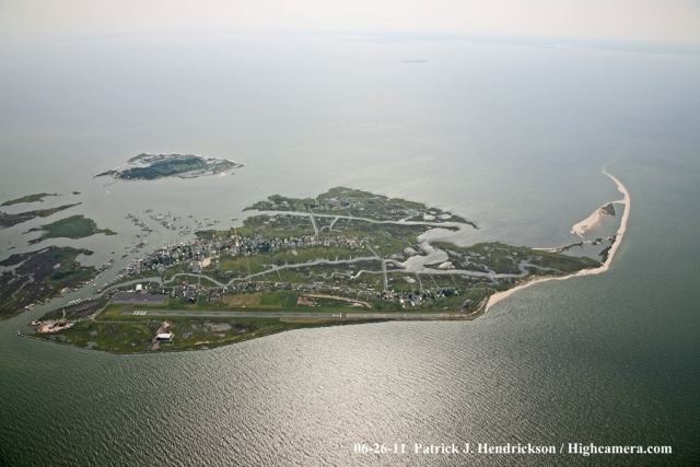
Geography
Tangier is located on an island in a part of the Chesapeake Bay called the Lower Eastern Shore. It is made up of many small islands divided by marshes and small tidal streams. The islands are connected by wooden bridges. The main island has three ridges, called Main Ridge, Canton, and West Ridge by the inhabitants. North of Tangier is an island which was abandoned after the stream between the two islands (Oyster Creek) became too wide to build a bridge over. This northernmost area is called Uppards, and originally had a neighborhood called Canaan. The only structures left on Uppards are duck hunting lodges from 1928. A few of the homes on Main Ridge were moved from Uppards before flooding became a major problem. Each of the ridges have neighborhoods. On the northern part of Main Ridge, the neighborhood is called Meat Soup. On the northern part of West Ridge it is called Sheep's Hill. On the southern part of Main Ridge it is called Black Dye, and on the southern part of West Ridge it is called Hog Ridge. Canton is in the most southeastern area of the island and is reached via a bridge from Black Dye. The bridges over the largest channel, called the Big Gut, are, to the south, Long Bridge, then coming north, School Bridge, and the farthest south is Heisten Bridge.
Because of its distance from the mainland, Tangier is very isolated, its nearest neighbors being other islands such as Smith Island, Maryland. The only methods of transportation off the island are boats and airplane. There is an airport, open from dawn to dusk. There are two boats that travel regularly from Crisfield, Maryland, across Tangier Sound to Tangier. Passengers and the mail are carried on these boats. The Courtney Thomas leaves Tangier at 8:00 am, and leaves Crisfield at 12:30 pm. The Steven Thomas, a 300-passenger cruise boat, leaves Crisfield at 12:30 pm during the summer season from Memorial Day weekend through mid-October; departs Tangier at 4:00 pm. In the summer season, the Chesapeake Breeze travels daily from Reedville, Virginia, on the Western Shore, leaving there at 10:00 am, and leaving Tangier at 2:00 pm. The service from Onancock was revived in 2009.
With all of these means of transportation, residents have regular ways of staying in touch with the mainland, and the addition of cable television keeps them in touch with the rest of the world. There is still a calm, peaceful atmosphere on the island, with only one pay phone, four or five gift shops, a few restaurants, and a hardware store as the only retail establishments. There are no arcades, no drug stores or department stores, no traffic lights, and violent crime is virtually nonexistent. There are three bed and breakfasts for overnight guests, and a wild beach without a boardwalk or concessions. There is one ATM on the island. Most of the gift shops, eating establishments, and overnight accommodations have begun to accept credit and debit cards. Attractions include a small museum in the back of Sandy's gift shop and a soft-shell crab exhibit next to Wanda's gift shop. Tangier is known for its seafood dishes, especially its soft-shell crab sandwiches. These can be found at its restaurants including the Waterfront Restaurant. Children sell lemonade and Rice Krispie treats and Christmas decorations made from sea shells to the tourists. In the evenings, the playground across from the school is a nice place for children to unwind, or the 1950s-style, centrally air conditioned ice-cream parlor on Main Ridge, called Spanky's.
The major new addition to the island has been the Tangier Island History Museum, which provides the island’s only public restrooms and created the historical markers that line Tangier’s streets and provide a “history tour” of the island. The museum’s artifacts are donated or loaned by local residents. The museum also operates a small community library, and provides free kayaks and maps for visitors to use from its dock out back to follow local “water trails”. This allows visitors to paddle around the watermen’s crabbing shacks built on stilts in Tangier Harbor, to navigate the saltwater “guts” that separate the island, or to visit “the Uppards”, a marshy island just to the north of Tangier that used to have a sizable community until it was abandoned to erosion in 1928. Immediately to the east of Tangier, also a kayak paddle away, is Port Isobel, a small island owned by the nonprofit Chesapeake Bay Foundation, which operates a major environmental study center there. Port Isobel’s hiking trails are open to the public but the low-lying marshland is ideal breeding grounds for mosquitoes and biting flies, so bug repellent is strongly recommended for anyone visiting the island.
There are few places in the United States with more waterfowl. Tangier marshes are home to many birds, including pelicans, blue herons, rails, egrets, several varieties of ducks and geese, and osprey.
Tangier is located at 37°49′33″N 75°59′32″W. According to the United States Census Bureau, the town has a total area of 1.2 square miles (3.2 km2), all of it land. The erosion of land by the sea is believed by many residents to threaten the existence of the island.
Including the surrounding marshes, Tangier Island totals less than 740 acres (300 hectares), but only 83 acres (34 hectares) are high enough for habitation. The highest point of land is barely four feet above sea level, and about 9 acres (3.6 hectares) of Tangier shoreline are estimated to erode into the Chesapeake each year. Local residents see their existence threatened from falling catches, due to worsening pollution in the Chesapeake Bay, constant erosion, and increasingly frequent flooding.
Language
The local accent is not unlike that of the "Hoi Toiders" of the Outer Banks of North Carolina, also settled by English settlers, many of whom still have descendants living on the islands today. Before bridges were built in the 1930s, the only form of transport between or off the islands was by boat, which allowed for the islands to stay isolated from much of the rest of the mainland. This helped to preserve the maritime culture and the distinctive Outer Banks brogue, which sounds more like a northern English, Scottish, or Irish accent than it does an American accent. Many "bankers" have often been mistaken for being from the UK or Ireland when traveling to areas outside of the Outer Banks. The brogue is most distinctive the further south one travels on the Outer Banks, with it being the thickest on Ocracoke Island and Harkers Island. Locally, the accent is called "Hoi Toider", in that the term "High tider" is pronounced with a distinctive "oy" in the hard "i", in common with the Westcountry dialect found in Southwest England.
Economy
Today, the inhabitants of Tangier rely on crabbing to make a living. Tangier is often referred to as the "soft-shell crab capital of the world". Most fishermen catch and sell crabs and oysters. North of the island are many free-standing docks not connected to land which fishermen use to hold crabs while they moult. Oystering is also a major industry. The island also has a long history of graduates joining the military.
The only industry on the island besides fishing is tourism. During the summer, several cruise ships come to the island each day, allowing passengers to explore and buy goods from the islanders. Two bed-and-breakfast inns can accommodate a limited number of overnight guests. There are several restaurants and gift shops for the tourist-trade. Some residents outfit golf carts with passenger trailers to sell "historical tours" of the island. The roads on Tangier are only wide enough for two golf carts to pass each other. Few cars are present on the island because they are not able to get over the small wooden bridges. Tourists and islanders all get around on golf carts, boats, mopeds, and bikes.
Isolation
Owing to the island's isolation, the resident's lifestyles are characterized as laid-back and "folksy." The isolation also contributes to the prevalence of Tangier disease, a recessive genetic disorder which causes high blood cholesterol that is named after the island's residents.
There is only one school on the island, with fewer than ten children in each grade. The residents were given access to cable television and Internet through a new microwave tower in spring 2010. There are phone lines on the island. Two doctors live on the island currently, but practice in Delaware. David Nichols treated residents for thirty years piloting a Cessna 182 or Robinson helicopter for once a week visits. In January 2007, he was profiled by ABC World News Tonight as its Person of the Week. Nichols died at the age of 62 on December 30, 2010, after a battle with cancer. Four months earlier, a new clinic was christened in his name. Emergency patients travel by helicopter to Crisfield or Salisbury hospitals in Maryland. Although the island has one power plant, it is mainly used for emergencies, but is operational. Power comes in from the Eastern Shore of Virginia.
Methodism has been and remains a very strong influence on Tangier, stemming from the charismatic preaching and revival camp meetings held there in the early 1800s by Joshua Thomas, the famed “parson of the islands.” Because of their ties to the Northern Methodist Church, Tangier residents did not support slavery and refused to join the rest of Virginia in seceding from the Union during the Civil War. Traditional religious values still dominate in the community, and a local ordinance prohibits the sale of alcohol. The Tangier town council blocked Warner Brothers from using the island to film the 1999 Kevin Costner film Message in a Bottle, objecting to the script’s drinking, profanity and sex. If visitors bring their own alcohol, they are advised to be discreet and not drink it in public.
Sports
According to the current mayor of Tangier, James "Ooker" Eskridge, many island inhabitants were concerned the way of life on the island would change as the result of getting high-speed Internet in spring 2010. However, he indicated the change was for the better as islanders "developed quite the appetite for streaming sports". Recognizing the impact of sports on the island community, and believing it may be a boost to the island's tourism, the Virginia Tourism Authority (VTA) declared Tangier Island the biggest sports town in America, per capita. The VTA presented the island with a plaque to commemorate the occasion. This phenomenon became the basis for a commercial for ESPN.
Demographics
As of the census of 2000, there were 605 people, 244 households, and 181 families residing in the town. The population density was 2,448.2 people per square mile (932.8/km2). There were 270 housing units at an average density of 1,094.4 per square mile (417.0/km2). The racial makeup of the town was 99.50% White and 0.50% African American. In 2006, there are four people from Eastern India, one African American, one Pacific Islander, and several people of American Indian extraction. A number of people have familial ties with residents of the Eastern Shore of Virginia.
There were 244 households out of which 27.5% had children under the age of 18 living with them, 61.1% were married couples living together, 9.4% had a female householder with no husband present, and 25.8% were non-families. 25.0% of all households were made up of individuals and 16.8% had someone living alone who was 65 years of age or older. The average household size was 2.48 and the average family size was 2.94.
In the town, the population was spread out with 21.5% under the age of 18, 6.6% from 18 to 24, 24.3% from 25 to 44, 29.0% from 45 to 64, and 18.5% who were 65 years of age or older. The median age was 43 years. For every 100 females there were 101.3 males. For every 100 females age 18 and over, there were 100.0 males.
The median income for a household in the town was $26,607, and the median income for a family was $28,636. Males had a median income of $19,167 versus $20,750 for females. The per capita income for the town was $24,042. About 22.6% of families and 27.5% of the population were below the poverty line, including 39.8% of those under age 18 and 12.8% of those age 65 or over.
Climate
The climate in this area is characterized by hot, humid summers and generally mild to cool winters. According to the Köppen Climate Classification system, Tangier has a humid subtropical climate, abbreviated "Cfa" on climate maps.