
Length 14 km | ||
 | ||
History: First section completed in June 1989,last section completed in August 1996 | ||
Tampines expressway from lorong halus to pasir ris drive 10
The Tampines Expressway (Abbreviation: TPE) is a highway in the north-eastern fringe of Singapore, joining the Pan Island Expressway (PIE) near Singapore Changi Airport in the east with the Central Expressway (CTE) and Seletar Expressway (SLE) in the north of the island.
Contents
- Tampines expressway from lorong halus to pasir ris drive 10
- Map of TPE Singapore
- Tampines expressway buses in torrential downpour 2016
- History
- References
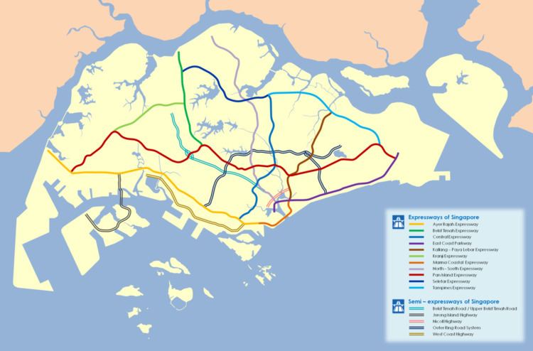
Map of TPE, Singapore
Tampines expressway buses in torrential downpour 2016
History
Concurrent to the development of Tampines New Town, the expressway was constructed in the 1980s. The original part of this expressway started at Elias Road and ended at the PIE, which was completed during the development of Tampines and Pasir Ris, this required demolishing the Pasir Ris Village with Jalan Guan Choon, followed by an extension to Tampines Road, which was completed on 2 June 1989.
Later extensions north-west were made to connect the TPE with the CTE and SLE so as to serve the newer residential areas of Sengkang and Punggol and provide a continuous expressway link between the northern and eastern parts of the island. It acquired much of Lorong Lumut, Lorong Halus Village, Cheng Lim Farmway, Jalan Kayu Village, Lorong Andong, Lorong Anchak and Boh Sua Tian Road. The expressway was opened in August 1996 after the Lorong Halus junction was completed.
In 1998, two new viaducts and a loop connecting the TPE and PIE were constructed to shorten the distance for motorists travelling from Pasir Ris and Tampines to Changi Airport.