
Range Western Ghats | ||
 | ||
Similar Western Ghats, Mulshi Dam, Malshej Ghat, Panshet Dam, Naneghat | ||
Tamhini Ghat is a mountain passage located between Mulshi and Tamhini in Maharashtra, India.
Contents
- Map of Tamhini Ghat Khandala Lonavala Maharashtra 410301
- Pursuit of Fresh Air on the way to Tamhini Ghat
- Road
- History
- References
Map of Tamhini Ghat, Khandala, Lonavala, Maharashtra 410301
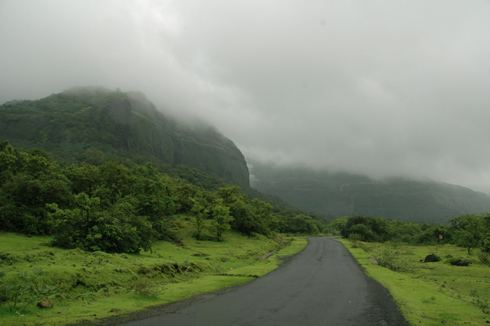
Situated on the crest of the Western Ghat mountain ranges, Tamhini Ghat is noted for its surroundings comprising scenic waterfalls, lakes and dense woods. The best time to visit is August and September. Tamhini Ghat starts from Mulshi Dam and ends at Orchard Cafe. There is a waterfall near Basho resort.
Pursuit of Fresh Air on the way to Tamhini Ghat
One should be careful when searching for Tamhini Ghat on the internet, because some maps (especially Google Maps) show an incorrect location. It is incorrectly shown that Tamhini Ghat is near Lonavala/Khandala. Google map lists this chat as Tamhini Ghat road.
Road
The Tamhini road ghat cuts the Sahyadri range to join Mulshi to Tamhini and makes the route in Konkan from Pune. This ghat stretches almost 15 km. The road is not very good, with a lot of potholed sections. The entire stretch becomes a popular destination during the monsoons. During the rainy season, the place transforms into a green bed with lots of waterfalls and small streams. There are state buses which ply through the ghat connecting Pune city with places on the Goa highway (NH17).
History
Tamhini Ghat did not exist earlier, as the whole area is under Tata Power. Considering the requirement of additional routes to take traffic in Konkan from Pune and Lonawala, this route was proposed.