
Local time Saturday 10:35 PM | ||
 | ||
Weather 23°C, Wind NE at 5 km/h, 67% Humidity | ||
Rio verde tamasopo huasteca and father serra missions
Tamasopo is a municipality and town in the Mexican state of San Luis Potosí. The town is located at 21°55′21″N 99°23′33″W. The municipality had an area of 1,329 square kilometres (513 sq mi) and a population of 28,848 in 2010, including the population of the town of Tamasopo with 4,326 people.
Contents
- Rio verde tamasopo huasteca and father serra missions
- Map of Tamasopo San Luis PotosC3AD Mexico
- Geography
- Climate
- History
- References
Map of Tamasopo, San Luis Potos%C3%AD, Mexico
Geography
Tamasopo is located in the foothills of the Sierra Madre Oriental. The town of Tamosopo has an elevation of 1,200 feet (370 m). The surrounding mountains rise to about 5,000 feet (1,500 mts) above sea level. Tamasopo is famous for its enchanting waterfalls in a lush rain forest
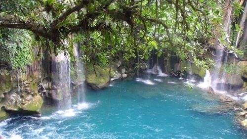
El Puente de Dios is two miles (3 km) northwest of Tamasopo town. It consists of waterfalls into a narrow gorge and cavern beneath an arch through which the Gallinas river runs rapidly. Blue and clear water pools for swimming are at the top and bottom of the cavern. The Cascada de Tamasopo is two miles (3 km) north of the town. It features three cascades tumbling about 20 metres (66 ft) into pools divided by travertine ledges and shelves. The character of the waterfalls reminds some travelers of Havasu Falls in the Grand Canyon. Nearby is El Trampolin which consists of small waterfalls falling into clear, deep pools in the midst of a tropical forest.
Climate
The climate of Tamasopo is classified as sub-tropical Cwa (Koppen) or Cwal (Trewartha).
History
Tamasopo is located in the Huasteca region, named after the indigenous people of the area. Indigenous people number 4,461 people in the municipality of whom 2,950 speak a native dialect . The indigenous population belongs mostly to two groups: the Huastecas who traditionally lived in the southern portion of the municipality and the Pame who lived in the northern part of the municipality.