
Length 77 km | Country United States of America | |
 | ||
Source Clay County, North Carolina | ||
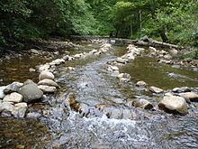
Big whithwater on the tallulah river north carolina
The Tallulah River is a 47.7-mile-long (76.8 km) river in Georgia and North Carolina. It begins in Clay County, North Carolina, near Standing Indian Mountain in the Southern Nantahala Wilderness and flows south into Georgia, crossing the state line into Towns County. The river then travels through Rabun County and ends in Habersham County. It cuts through the Tallulah Dome rock formation to form the Tallulah Gorge and its several waterfalls (collectively known as Tallulah Falls). The Tallulah River intersects with the Chattooga River to form the Tugaloo River at Lake Tugalo in Habersham County, which then joins South Carolina's Seneca River at Lake Hartwell to create the Savannah River which flows southeastward into the Atlantic Ocean.
Contents
- Big whithwater on the tallulah river north carolina
- Map of Tallulah River South Carolina USA
- References
Map of Tallulah River, South Carolina, USA
From its headwaters to its confluence with the Tugaloo River, the Tallulah River is approximately 48 miles (77 km) long. The Tallulah River Basin drains approximately 184 square miles (480 km2), as measured at the Tallulah Falls Hydroelectric Plant in Habersham County, Georgia, near the lower end of the Tallulah Gorge. The lower part of the river includes a string of man-made lakes along the river created by hydroelectric dams operated by Georgia Power. The first (and northernmost) lake in the series is Lake Burton, which is followed by Lake Seed, Lake Rabun, and Lake Tallulah Falls. From Tallulah Falls Lake, the lower part of the river flows through the Tallulah Gorge and now ends as an arm of Lake Tugalo, the other arm of the lake being formed by the Chattooga River. Starting at a point about 0.5 miles (0.80 km) downstream from the dam for Tallulah Falls Lake, the boundary line between Habersham and Rabun counties follows the course of the Tallulah River to its end.
The upper Tallulah River Basin drains to the portion of the Tallulah River that is upstream from Lake Burton and includes northwestern Rabun County, northeastern Towns County and part of Clay County, North Carolina. The United States Geological Survey collects data for the upper Tallulah River Basin from its gauging station at the point where the river crosses Plum Orchard Road. The upper Tallulah River Basin includes a section of the river that is about 14.3 miles (23 km) long, draining a 56.5 square mile (146 km²) area. Annually, the area receives at least 72 inches of rainfall and is entirely within the boundaries of the Chattahoochee National Forest, with about one third of the land falling in the Southern Nantahala Wilderness and about one fifth privately owned. The primary tributaries of the Tallulah River in Rabun County are Coleman River and Persimmon Creek.
The upper Tallulah River Basin is as scenic as it is rugged. The highest elevations are found in North Carolina on Standing Indian Mountain, elevation 5,499 feet, where the Tallulah River headwaters are located. After coming into Georgia and passing through the old mining and logging town of Tate City, Georgia in eastern Towns County, the river enters into to what some people call Tallulah’s upper gorge or the Rock Mountain Gorge. This upper "gorge" is far less dramatic that the more famous Tallulah Gorge, but it starts just upstream from the river’s confluence with Coleman River and runs nearly 3 miles (5 km) past Rock Mountain on the western side of the river. The scenic "gorge" is accessible via a drive along the Tallulah River Road (Forest Service Road 70). The Tallulah River Road follows an old railroad bed before ending in the Southern Nantahala Wilderness and provides the only access to Tate City. Heavily wooded today, the upper Tallulah River Basin was stripped nearly bare by logging in the 1930s before the establishment of the Chattahoochee National Forest.
Because Georgians long have assumed that Tallulah was a Cherokee word, there is no agreement regarding the derivation of the name for the Tallulah River. Tourism promoters in the late 19th century described the word Tallulah as meaning "thundering waters" in Cherokee. Some scholars later theorized that tallulah meant “terrible” in Cherokee or was possibly derived from a number of other words, but it is more likely that there is no translation for the word. It actually has no meaning in Cherokee. The most likely source of the word is the Okonee (a branch of the Creek Indians) word talula, which means "town". The Okonee People occupied northeastern Georgia and northwestern South Carolina for hundreds of years prior to the arrival of the Cherokees in the early 18th century. There was a Cherokee Over-the-Hill settlement called Tallulah located on the upper portion of the river.