
Elevation 39 m (128 ft) Time zone CET (UTC+1) Dialling code 0184 | Demonym(s) Taggiaschi or Tabiesi Area 30.87 km² Local time Saturday 6:09 AM Postal code 18018 | |
 | ||
Frazioni Arma di Taggia, Borghi, Levà Weather 16°C, Wind N at 24 km/h, 63% Humidity | ||
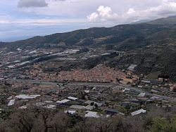
Taggia is a comune (municipality) in the Province of Imperia in the Italian region Liguria, located about 110 kilometres (68 miles) southwest of Genoa and about 15 km (9 mi) west of Imperia. It has around 13,000 inhabitants.
Contents
Map of 18018 Taggia Province of Imperia, Italy
Taggia borders the following municipalities: Badalucco, Castellaro, Ceriana, Dolcedo, Pietrabruna, Riva Ligure, and Sanremo.
Geography
The town is divided into three parts: Taggia proper, the historical centre, in the Valle Argentina; Levà, including the industrial area; and Arma, a sea resort.
History
Tombs dating from the 10th-7th centuries BC have been found in the area of Taggia. During the Roman domination it was an important commercial port, known as Costa Balenae. After the fall of the Western Roman Empire, the old centre was damaged by the invasion of Rotharis's Lombards and then by a landslide in 690. The inhabitants moved to a new walled settlement, called Tabia. Despite its defences, in 889 it was sacked and razed to the ground by the Saracens
The rebuilt burgh became in 1153 a fief of the Clavesana family, but soon later it was acquired by the Republic of Genoa. In 1273 it became an autonomous commune, later receiving a podestà named in Genoa, under which it remained until its disappearing in the Napoleonic Wars. Later it was part of the Kingdom of Sardinia (1815) and of the Kingdom of Italy (1861).
Main sights
Transport
Taggia is situated on the Via Aurelia (now a provincial road). It has also a gate on the A10 Highway.
Taggia has a railway station on the Genoa–Ventimiglia line.