
Country United States Area code(s) 539/918 Elevation 178 m Zip code 74463 Local time Friday 11:18 PM | Time zone Central (CST) (UTC-6) FIPS code 40-72050 Area 3.9 km² Population 248 (2013) | |
 | ||
Weather 16°C, Wind SE at 11 km/h, 86% Humidity | ||
Taft is a town in Muskogee County, Oklahoma, United States. The population was 250 at the 2010 census, a decline of 28.4 percent from 349 at the 2000 census. The town began as an all-black town on land allotted to Creek Freedmen. It is named for President William Howard Taft.
Contents
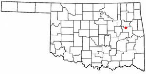
Map of Taft, OK, USA
History
This community began as an all-Black town on land allotted to freedmen of the Creek Nation. It was originally named Twine, for William H. Twine, and had a post office by 1902. Twine moved to Muskogee, and the citizens voted to rename the town as Taft, for President William Howard Taft, who was then Secretary of War in the Theodore Roosevelt administration.
Educational and correctional facilities have long been the town's leading employers. These have included: W. T. Vernon School (1908), the Industrial Institute for the Deaf, Blind, and Orphans of the Colored Race (1909), Moton High School, and the State Training School for Negro Girls.
Taft also contains two penitentiaries: Dr. Eddie Warrior Correctional Center, for women, and Jess Dunn Correctional Center, for men.
Geography
Taft is located at 35°45′45″N 95°32′46″W (35.762595, -95.546046). It is about 8 miles (13 km) west of the city of Muskogee. According to the United States Census Bureau, the town has a total area of 1.5 square miles (3.9 km2), all of it land.
Demographics
As of the census of 2000, there were 349 people, 136 households, and 87 families residing in the town. The population density was 227.8 people per square mile (88.1/km²). There were 155 housing units at an average density of 101.2 per square mile (39.1/km²). The racial makeup of the town was 85.39% African American, 3.72% White, 1.15% Native American, 0.29% from other races, and 9.46% from two or more races. Hispanic or Latino of any race were 0.57% of the population.
There were 136 households out of which 33.1% had children under the age of 18 living with them, 36.0% were married couples living together, 23.5% had a female householder with no husband present, and 35.3% were non-families. 31.6% of all households were made up of individuals and 12.5% had someone living alone who was 65 years of age or older. The average household size was 2.57 and the average family size was 3.30.
In the town, the population was spread out with 35.0% under the age of 18, 7.2% from 18 to 24, 20.1% from 25 to 44, 19.8% from 45 to 64, and 18.1% who were 65 years of age or older. The median age was 36 years. For every 100 females there were 75.4 males. For every 100 females age 18 and over, there were 65.7 males.
The median income for a household in the town was $18,889, and the median income for a family was $26,500. Males had a median income of $20,417 versus $17,813 for females. The per capita income for the town was $11,278. About 23.0% of families and 33.7% of the population were below the poverty line, including 44.4% of those under age 18 and 18.8% of those age 65 or over.