
 | ||
Ta on strait biodiversity management bureau
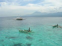
Tañon Strait (Filipino: Kipot ng Tanon) lies between the islands of Negros and Cebu in the Philippines. The strait, which is about 161 km (100 miles) long, connects the Visayan Sea in the north to the Bohol Sea in the south. Its width varies from 5 to 27 kilometres (3 to 17 mi), with the narrowest point in the south. In the north the strait is closed off by the Don Islands, the largest of which is Bantayan. The cities of Bais, Negros Oriental and Toledo, Cebu have deepwater port facilities. The Tañon Strait is known for whale‑ and dolphin‑watching, with tour boats operating from Bais City.
Contents
- Ta on strait biodiversity management bureau
- Map of TaC3B1on Strait Philippines
- The story of ta on strait
- Protected area
- Controversy
- References
Map of Ta%C3%B1on Strait, Philippines
The story of ta on strait
Protected area
The Tañon Strait protected seascape was established by President Ramos under Proclamation No. 1234 of 1998.
Controversy
On February 7, 2008 the Supreme Court of the Philippines ordered the Department of Environment and Natural Resources and the Department of Energy to comment on a certiorari petition filed for baleen and toothed whales, dolphins, porpoises including the Irrawaddy Dolphins, and other cetacean species in the Tañon Strait to stop oil exploration by Japan Petroleum Exploration Co. Ltd. (JAPEX) in the protected waterway. The strait serves as a marine wildlife reserve that provides grounds for breeding, feeding and resting to 11 species of marine mammals. The court was asked to recognize the petitioners as "Filipino mammals" with constitutional rights.
JAPEX subsequently abandoned oil exploration in the area, saying that initial drilling had shown lack of commercial opportunity. However the Supreme Court case continued.