
Passengers 85 Survivors 0 Registration N54328 Survivor 0 | Crew 7 Start date December 1, 1974 Fatalities 92 (all) Passenger count 85 | |
 | ||
Summary Controlled flight into terrain Similar TWA Flight 841, TWA Flight 128, TWA Flight 159, TWA Flight 513, 1965 Carmel mid‑air co | ||
The crash of twa flight 514 mov
Trans World Airlines Flight 514, registration N54328, was a Boeing 727-231 en route from Indianapolis, Indiana, and Columbus, Ohio, to Washington Dulles International that crashed into Mount Weather, Virginia, on December 1, 1974. All 85 passengers and 7 crew members were killed.
Contents
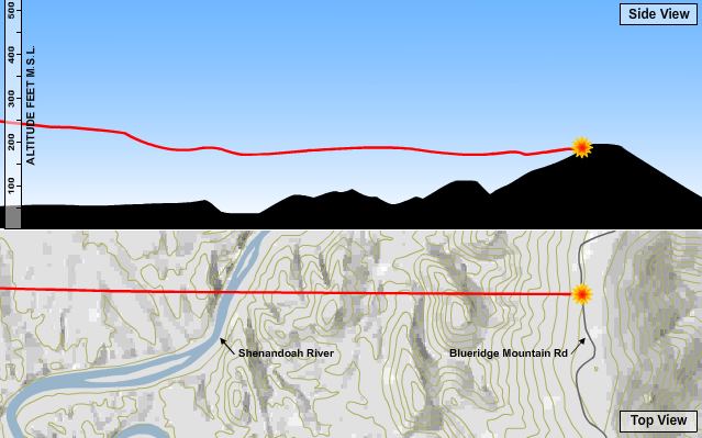
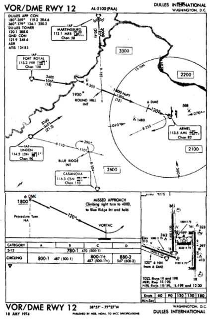
The flight was originally destined for Washington National Airport. However, the plane diverted to Dulles when high crosswinds, east at 28 knots (52 km/h) and gusting to 49 knots (91 km/h), prevented safe operations on the main north-south runway at Washington National. The flight was being vectored for a non-precision instrument approach to runway 12 at Dulles. Air traffic controllers cleared the flight down to 7,000 feet (2,100 m) before clearing them for the approach while not on a published segment.

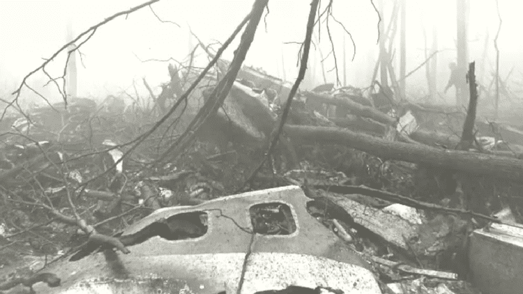
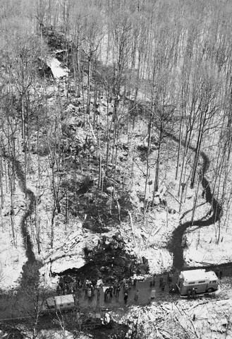
The jetliner began a descent to 1,800 feet (550 m) shown on the first checkpoint for the published approach. The data recorder indicated there was some confusion in the cockpit over whether they were still under a radar controlled approach segment which would allow them to descend safely. After reaching 1,800 feet (550 m) there were some 100-to-200-foot (30 to 60 m) altitude deviations which the flight crew discussed as encountering heavy downdrafts and reduced visibility in snow. The plane impacted the west slope of Mount Weather at 1,670 feet (509 m) above sea level at approximately 230 knots (430 km/h; 260 mph). The wreckage was contained within an area about 900 feet (270 m) long and 200 feet (61 m) wide. The evidence of first impact was trees whose tops were cut off about 70 feet (21 m) feet above the ground. The elevation at the base of the trees was 1,650 feet (500 m). The wreckage path was oriented along a line 118 degrees magnetic. Calculations indicated that the left wing went down about 6 degrees as the aircraft passed through the trees and the aircraft was descending at an angle of about 1 degree. After about 500 feet (150 m) of travel through the trees, the aircraft struck a rock outcropping at an elevation of about 1,675 feet (511 m). Numerous heavy components of the aircraft were thrown forward of the outcropping. Numerous intense post-impact fires were located, and extinguished. The mountain's summit is at 1,754 feet (535 m).

The accident investigation board was split in its decision as to whether the flight crew or Air Traffic Control were responsible. The majority absolved the controllers as the plane was not on a published approach segment. The dissenting opinion was that the flight had been radar vectored. Terminology between pilots and controllers differed without either group being aware of the discrepancy. It was common practice at the time for controllers to release a flight to its own navigation with "Cleared for the approach," and flight crews commonly believed that was also authorization to descend to the altitude at which the final segment of the approach began. No clear indication had been given by controllers to Flight 514 that they were no longer on a radar vector segment and therefore responsible for their own navigation. Procedures were clarified after this accident. Controllers now state, "Maintain (specified altitude) until established on a portion of the approach," and pilots now understand that previously assigned altitudes prevail until an altitude change is authorized on the published approach segment the aircraft is currently flying. Ground proximity detection equipment was also mandated for the airlines.
During the NTSB investigation, it was discovered that a United Airlines flight had very narrowly escaped the same fate during the same approach and at the same location only six weeks prior.
The flight is also of note in that the accident drew undesired attention to the Mount Weather facility, which was the linchpin of plans implemented by the United States to ensure continuity of government in the event of a nuclear war. The crash did not damage the facility, since most of its features were underground. Only the facility's underground main phone line was severed, with service to the complex being restored by C&P Telephone within 2½ hours after the crash.
The crash, its aftermath, and its repercussions are the subject of the 1977 book Sound of Impact: The Legacy of TWA Flight 514 by Adam Shaw. TWA Flight 514 is also mentioned in the closing of the second chapter of Mark Oliver Everett's book Things the Grandchildren Should Know and in F. Lee Bailey's book Cleared for Approach: In Defense of Flying. In 2015, a documentary entitled Diverted: TWA 514 was released.
This was one of two Boeing 727s to crash in the United States that day; the other was Northwest Airlines Flight 6231.
U.S. Congressman Andy Jacobs was almost on the flight, but elected not to pay the $20 seat upgrade charge and decided to take another flight back to Washington. One of his staff was killed on the flight.