
Status In Service In use 1959–present | Built Unknown | |
 | ||
Type FEMA command center, permanent Executive Branch substitute Address Blue Ridge Mountain Rd, Bluemont, VA 20135, USA Hours Open today · Open 24 hoursMondayOpen 24 hoursTuesdayOpen 24 hoursWednesdayOpen 24 hoursThursdayOpen 24 hoursFridayOpen 24 hoursSaturdayOpen 24 hoursSundayOpen 24 hours Controlled by United States Department of Homeland Security Similar Bluemont Vineyard, Sky Meadows State Park, John H Enders Fire Company, Blue Ridge Volunteer Fire Co, Clarke County Sheriff's | ||
Mount weather emergency operations center
The Mount Weather Emergency Operations Center is a civilian command facility in the U.S. Commonwealth of Virginia, used as the center of operations for the Federal Emergency Management Agency (FEMA). Also known as the High Point Special Facility (HPSF), its preferred designation since 1991 is "SF".
Contents
- Mount weather emergency operations center
- Location
- Evacuations
- In the media
- In popular culture
- References
The facility is a major relocation site for the highest level of civilian and military officials in case of national disaster, playing a major role in continuity of government (per the U.S. Continuity of Operations Plan).
Mount Weather is the location of a control station for the FEMA National Radio System (FNARS), a high frequency radio system connecting most federal public safety agencies and the U.S. military with most of the states. FNARS allows the president to access the Emergency Alert System.
The site was brought into the public eye by The Washington Post, when the government facility was mentioned while reporting on the December 1, 1974, crash into Mount Weather of TWA Flight 514, a Boeing 727 jetliner.
Location
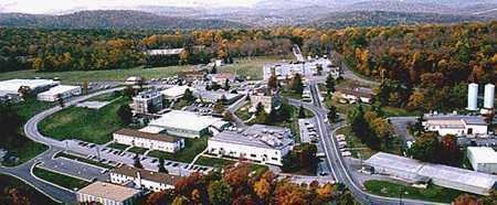
Located in the Blue Ridge Mountains, access to the operations center is available via State Route 601 (also called Blueridge Mountain Road) in Bluemont, Virginia. The facility is located near Berryville, 48 miles (77 km) west of Washington, D.C.
The site was originally opened as a weather station in the late 1800s. It was used as a Civilian Public Service facility (Camp #114) during World War II. At that time there were just two permanent buildings on the site: the administration/dormitory building, and the laboratory. Those buildings still stand, supplemented by many more modern buildings.
The underground facility within Mount Weather, designated "Area B", was completed in 1959. FEMA established training facilities on the mountain's surface ("Area A") in 1979.
The above-ground portion of the FEMA complex (Area A) is at least 434 acres (176 ha). This measurement includes a training area of unspecified size. Area B, the underground component, contains 600,000 square feet (56,000 m2).
Evacuations
According to a letter to the editor of The Washington Post, after the September 11 attacks, most of the congressional leadership was evacuated to Mount Weather by helicopter.
Between 1979 and 1981, the National Gallery of Art developed a program to transport valuable paintings in its collection to Mount Weather via helicopter. The success of the relocation would depend upon how far in advance warning of an attack was received.
In the media
The first video of Mount Weather shot from the air to be broadcast on national TV was filmed by ABC News producer Bill Lichtenstein, and was included in the 1983 20/20 segment "Nuclear Preparation: Can We Survive", featuring 20/20 correspondent Tom Jarriel. Lichtenstein flew over the Mt. Weather facility with an ABC camera crew. The news magazine report also included House Majority Leader Tip O'Neill and Representative Ed Markey, confirming that there were contingency plans for the relocation of the United States government in the event of a nuclear war or major disaster.
Both Mount Weather and the now deactivated The Greenbrier were featured in the A&E documentary Bunkers. The documentary, first broadcast on October 23, 2001, features extensive interviews with engineers and political and intelligence analysts, providing rare insights into the secret installations. The documentary compared The Greenbrier and Mount Weather to Saddam Hussein's control bunker buried beneath Baghdad. The documentary features interior video of The Greenbrier as well as the Baghdad bunker, which survived direct hits from seven Joint Direct Attack Munition bombs during the Battle of Baghdad in 2003.
Author William Poundstone investigated Mount Weather in his 1989 book Bigger Secrets.
In popular culture
The novel Seven Days in May mentions a facility called Mount Thunder, a reference to Mount Weather, but the road descriptions in the book make it quite clear that it is the same facility. It is also referenced in the movie based on the book, filmed during the Kennedy Administration and released in 1964.
Mount Weather is mentioned briefly in Thirteen Days, a 2000 dramatization of the Cuban Missile Crisis.
In the 2008 remake of the The Day the Earth Stood Still, Mount Weather is used as the underground facility where GORT is examined by the military, and where they try to destroy him.
Mount Weather is the attempted landing site in the beginning of the first of the The 100 novel series and a 2014 television series based on it. It later becomes the setting of much of the second and third books Day 21 and Homecoming, and the television series' second season.