
Time zone CET (UTC+1) Area 34.26 km² Local time Tuesday 4:49 AM | County Veszprém Postal code 8264 Population 936 (2004) Area code 87 | |
 | ||
Weather 10°C, Wind NW at 13 km/h, 79% Humidity Points of interest Lake Balaton, Szigliget, Eszterházy Pince Szigliget, Szent Antal Pince | ||
Szigliget is a village in Veszprém county, Hungary.
Contents
- Map of Szigliget Hungary
- Settings
- History
- Avas church ruins
- Castle Szigliget
- The manor of Count Esterhzy
- References
Map of Szigliget, Hungary
Settings
The village can be found on the northern bank of Lake Balaton in the vicinity of Badacsony and Keszthely. The village was built between and on volcanic hills. It can be reached by car on the 71 highway or by train on the Székesfehérvár–Tapolca-railway stopping at Badacsonytördemic-Szigliget station.
History
The settlement existed in the Neolithic and Bronze Ages. Celtic, Roman and Avar archaeological finds were discovered in the vicinity. The ruins of a parochial church, built in the 12th century, can be seen. Until 1822 the area was an island in Lake Balaton. The island was connected to the mainland in 1822 by rearrangement of the bank-dams around Balaton.
Avas church ruins
The church was built in the Árpád era (12th century), of basalt. The old tower is still standing.
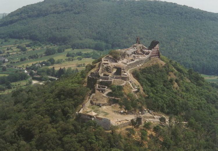
Castle Szigliget
The ruins of the medieval fortress stand atop the 239m Várhegy hill. Recently restored, the castle looks out on a panorama of Lake Balaton toward the Tapolca Basin. Poets have praised the beauty of the village and landscape.
The manor of Count Esterházy
The manor house, built in the 19th century by the House of Esterházy, is a modern home for artists, surrounded by the arboretum of 9,2 hectares.