
Seat Malmesbury Time zone SAST (UTC+2) Area 3,707 km² Black african population 18.3% Native english speakers 4.7% | Wards 12 Municipal code WC015 White population 15.6% Native afrikaans speakers 82.8% Native sotho speakers 1.5% | |
 | ||
Rare cars for sale swartland local municipality south africa
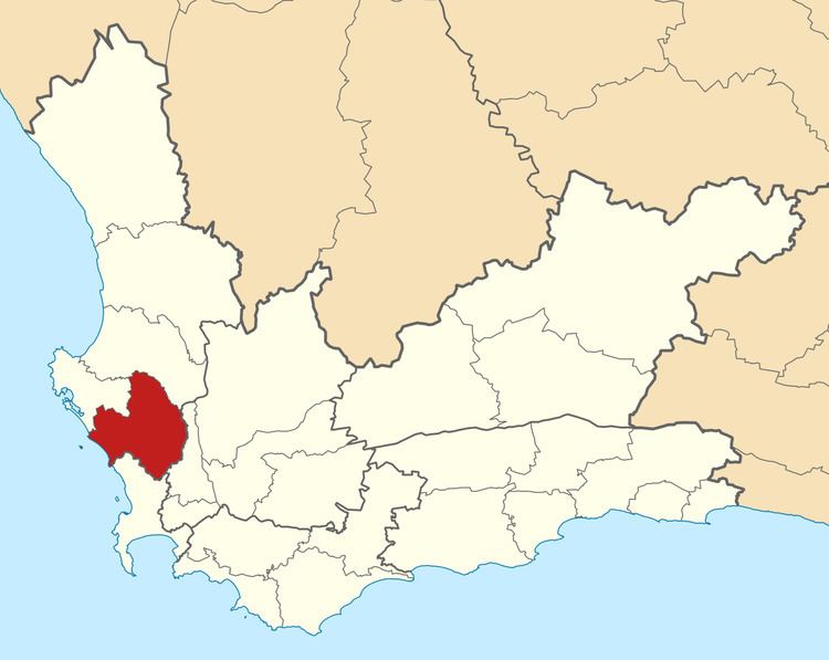
Swartland Municipality is a municipality located in the Western Cape Province of South Africa. Malmesbury is the seat of the municipality. As of 2011, it had a population of 113,762. Its municipality code is WC015.
Contents
Vintage cars for sale swartland local municipality south africa
Geography
The municipality covers an area of 3,707 square kilometres (1,431 sq mi), stretching from the Atlantic Ocean in the west to the Berg River in the east. To the south it abuts on the City of Cape Town, to the east the Drakenstein Municipality, and to the north the Bergrivier Municipality and Saldanha Bay Municipality.
According to the 2011 census the municipality has a population of 113,762 people in 29,324 households. Of this population, 64.8% describe themselves as "Coloured", 18.3% as "Black African", and 15.6% as "White". The first language of 82.8% of the population is Afrikaans, while 8.9% speak Xhosa, 4.7% speak English and 1.5% speak Sotho.
The principal town and seat of the council is Malmesbury, which is situated in the south-east of the municipality and has a population (according to the 2011 census) of 25,176. Other large towns are Moorreesburg (pop. 12,877) to the north, and Darling (pop. 10,420) to the west. In the Riebeek Valley north-east of Malmesbury are the sister towns of Riebeek-Kasteel (pop. 4,761) and Riebeek West (pop. 4,350).
In the vicinity of Malmesbury there are the smaller agricultural villages of Abbotsdale, Chatsworth, Kalbaskraal and Riverlands, while in the vicinity of Moorreesburg are found the villages of Klipfontyn and Koringberg. Yzerfontein on the Atlantic coast is a fishing village and holiday town.
Economic Base
Malmesbury is the administrative centre of the Municipality and fulfils an important urban niche in the region and the province. Its high development potential can be attributed to factors such as its relative accessibility along the N7 road/rail corridor; closeness to Cape Town; diversified economic base, which not only accommodates agriculture but also well-developed industrial and commercial sectors; and supportive infrastructure. Malmesbury is home to a number of large companies, as well as regional offices of provincial and national government departments.
In 2011 the main contributors to the regional GDP were: Finance, insurance, real estate and business services (33.7%), manufacturing (21.2%), agriculture, forestry and fishing (14.3%) and wholesale and retail trade, catering and accommodation (11%).
Politics
The municipal council consists of twenty-three members elected by mixed-member proportional representation. Twelve councillors are elected by first-past-the-post voting in twelve wards, while the remaining eleven are chosen from party lists so that the total number of party representatives is proportional to the number of votes received. In the election of 18 May 2011 the Democratic Alliance (DA) obtained a majority of fifteen seats on the council.
The following table shows the results of the 2011 election.
The local council sends four representatives to the council of the West Coast District Municipality: three from the Democratic Alliance and one from the African National Congress.