
Population 254 (2011 Census) Civil parish Swalcliffe Area 6.79 km² Dialling code 01295 | OS grid reference SP3737 Sovereign state United Kingdom Local time Sunday 1:27 AM | |
 | ||
Weather 6°C, Wind NW at 11 km/h, 92% Humidity | ||
Swalcliffe is a village and civil parish about 5 miles (8 km) west of Banbury in Oxfordshire. The parish is about 2 1⁄2 miles (4 km) long north–south and about 1 mile (1.6 km) east–west. The 2011 Census recorded the population of the modern Swalcliffe parish as 210.
Contents
Map of Swalcliffe, UK
The toponym "Swalcliffe" comes from the Old English swealwe and clif, meaning a slope or cliff frequented by swallows. The ancient parish of Swalcliffe was larger than the present civil parish, and included the townships of Epwell, Shutford, Sibford Ferris and Sibford Gower.
Archaeology
About 3⁄4 mile (1.2 km) northeast of the village are the remains of an Iron Age hill fort on Madmarston Hill and the site of a Roman villa at Swalcliffe Lea. The hill fort is a Scheduled Ancient Monument. The site of the villa is close to the course of a former Roman road running approximately east–west. Its course is now a bridleway. One authority asserts that there was a Roman or Romano-British village here.
Manor
Swalcliffe Manor house has a 13th-century service wing and a 14th-century hall. In the 16th century the hall was divided up and a solar was added. The house has later additions including a 20th-century extension. It is a Grade I listed building.
Parish church
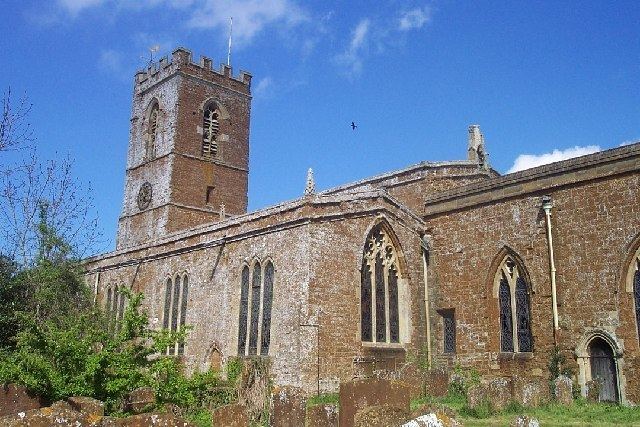
The Church of England parish church of SS Peter and Paul is Anglo-Saxon in origin but was rebuilt in the 12th and 14th centuries. The bell tower was built in the 13th century and made higher in the 15th century. The church is a Grade I listed building.
The tower has a ring of six bells cast by Matthew I Bagley and Henry II Bagley of Chacombe, Northamptonshire in 1685. Richard Sanders of Bromsgrove recast one of them in 1720.
SS Peter and Paul's parish is a member of the Benefice of Wykeham, along with the parishes of Broughton, Epwell, Shutford, Sibford Gower and Tadmarton.
Tithe barn
Swalcliffe tithe barn was built for New College, Oxford in 1401–07. It has an almost completely intact medieval timber half-cruck roof and is considered the finest medieval tithe barn in Oxfordshire and one of the best examples in England. It is a Grade I listed building and a Scheduled Ancient Monument.
The barn is open free of charge on Sundays from Easter to October and houses part of the Oxfordshire Museum's collection of traditional agricultural and trade vehicles and an exhibition of 2,500 years of Swalcliffe history. The building has similarities to the tithe barns at Adderbury and Upper Heyford, which also were built for New College around the beginning of the 15th century.
Air crash
On 31 May 1944 a Vickers Wellington B Mk III bomber aircraft, BK157 of No. 12 Operational Training Unit RAF based at Chipping Warden in Northamptonshire, was on a training flight over north Oxfordshire when the pilot, F/O Donald Driver, DFM, made an evasive diving turn to port. The port wing collapsed and the aircraft crashed at Swalcliffe. It burst into flames and all seven crew were killed.
The crew were members of the Royal Air Force Volunteer Reserve. F/O Driver and one of the air gunners are buried in Southam Road Cemetery in Banbury, which has a Commonwealth War Graves section. Other members of the crew are buried at Downpatrick in County Down, Hounslow in Middlesex, Huntly in Aberdeenshire, Titchfield in Hampshire and Wick in Caithness.
This aircraft actually crashed in the neighbouring village of Tadmarton, where there is a memorial stone marking the crash.
Amenities
Swalcliffe has a 17th-century public house, The Stag's Head. There is also a village hall.
There is also a boarding school, Swalcliffe Park School, for boys with special educational needs.
Stagecoach in Warwickshire bus 50A to Banbury and Stratford-Upon-Avon serves Swalcliffe several times a day.