
Time zone EST (UTC-5) Area code Area code 905 | Demonym(s) Suttonian Forward sortation area L0E | |
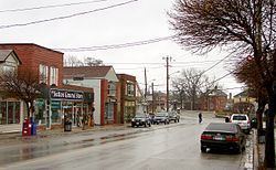 | ||
Sutton is a suburban community located nearly 2 km south of Lake Simcoe in Ontario, Canada. The community was formerly a village but is now part of the Town of Georgina after amalgamation with it and North Gwillimbury in 1971.
Contents
- Map of Sutton Georgina ON Canada
- Geography and information
- History
- Sibbald Point Provincial Park
- Pioneer Village
- Beaches
- Sutton Fair and Horse Show
- Canada Day
- Santa Claus Parade of Lights
- Nearest places
- References
Map of Sutton, Georgina, ON, Canada
Geography and information
Sutton is located in the Regional Municipality of York, and is situated around a small river, the Black River, that flows from the south and East. Sutton is passed by a road linking Woodbine Avenue and the highway linking Toronto and Beaverton (Highway 48) forming a T junction to the southeast. The nearest superhighway is Highway 404 to the southwest which was extended to reach Keswick, Ontario in 2014 at Ravenshoe road and Woodbine Ave. Woodbine Avenue runs from Steeles Avenue at the Toronto-Markham border all the way to Lake drive in Georgina when the road curves and turns into Baseline Road. The road known as Baseline Road connects Sutton to Keswick. Sutton was once bounded with the old township of North Gwillimbury to the west. From the amalgamation, Sutton is in the central part of Georgina. The Canadian National rail runs south of Sutton and links with Toronto and Orillia as well as Northern Ontario. Sutton is located E of Keswick, about 25 to 30 km SW of Beaverton, S of Orillia, W of Lindsay, about 12 to 15 km N of Mount Albert, about 70 to 75 km N of Toronto and about 35 km NE of Newmarket.
Sutton is sandwiched between forests and farmlands. A large forest dominates the south and southeast covering about 50 to 100 km² directly outside Sutton. The forest are mainly made up of pine and other varieties of trees. Farmlands cover the west and southwest dominating about 50 km² and to the east. The downtown streets are aligned at a 45° angle. Snake Island is situated to the northwest. A small bay is to the northeast.
Housing developments came in the mid-20th century to the northern part and continued slowly until the 1980s. The subdivision 2 km to the east continued in the 1980s and the early-1990s whereas each street is alphabetized from A to L. Housing projects later slowed in the 1990s and the 2000s and the population has slowed. Cottages are also found in the area located along the shore of Lake Simcoe.
History
The first inhabitants were Aboriginal people, as Sutton was a rich area for hunting, fishing, and gathering thousands of years ago.
Sibbald Point Provincial Park
Sibbald Point Provincial Park is a day use and campground facility, with a large sandy beach, electrical and non-electrical sites, hiking trails, boating access to Lake Simcoe, and the Sibbald Family Museum.
Pioneer Village
Located near the shore of Lake Simcoe, the Pioneer Village is a 10-acre space with many buildings to teach the history of Georgina between the years of 1850 and 1920. There is a one-room school house, general store, train station, blacksmith shop, an apothecary and a log house. They also have many archives including family documents, land records, photos, and scrapbooks. The Pioneer village holds tours, camps, workshops, and other events throughout the season. Admission is granted by donation unless specified for a certain event.
Beaches
Sutton is home to many beaches including De La Salle Park, Holmes Point Park, Jackson's Point/Bonnie Park, North Gwillimbury Park, Willow Beach Conservation Area, Willow Wharf, and Young's Harbour. These areas are extremely popular in the summer months, attracting tourism, holding sports, activities and events.
Sutton Fair and Horse Show
The Sutton Fair & Horse Show is an annual event that takes place at the fairgrounds located near the Sutton arena. The four-day event on the second weekend in August is put on by the Sutton Agricultural Society. The Sutton Fair is held at the Sutton Fair Grounds which are located at 3 Fairpark Lane, in Sutton West, Ontario, Canada. Sutton is located in York Region, Ontario, just north of Toronto. The event grounds are available for rental during the rest of the year. The location offers parking onsite, 2 pavilions, 3 horse rings (1 dirt and 2 grass rings), race track, outdoor stage, ticket booths, barricades/gates and more. The fair contains a variety of events including Horse & Livestock Competitions, Home craft Exhibits, Truck & Tractor Pull, Dog Show, Horse Pull, Demolition Derby, Worlds Finest Midway. Arena displays and vendors set up all around the premises are sure to have something that will catch your eye.
Canada Day
With the new ROC (Recreational Outdoors Centre), Canada Day festivities are held in a much larger and accommodating space. Live entertainment, children's activities, food, Ribfest, and fireworks are the main attractions.
Santa Claus Parade of Lights
The annual Santa Clause Parade of Lights takes place beginning at 5pm to makes Christmas lights shine on the floats. The parade begins at Lake Drive East and Dalton Road and ends at the Sutton Fairgrounds.