
 | ||
Suruga Bay (駿河湾, Suruga-wan) is a bay on the Pacific coast of Honshu in Shizuoka Prefecture, Japan. It is situated north of an imaginary line joining Omaezaki Point and Irōzaki Point at the tip of the Izu Peninsula and surrounded by Honshū to the southwest and west and the Izu Peninsula to the east.
Contents
Map of Suruga Bay, Japan
Geology
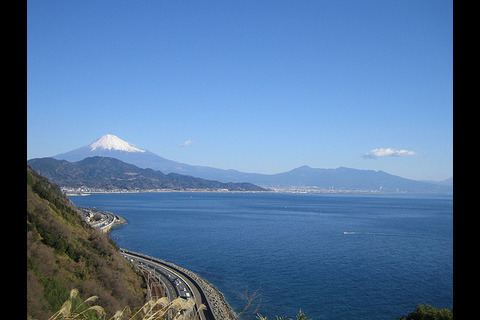
Suruga Bay is a place of contrasts. Japan's loftiest peak, Mount Fuji at 3,776 metres (12,388 ft), rises from the 2,500 metres (8,200 ft) depth of the Suruga Trough running up the middle of the bay, which makes it Japan's deepest. Numerous rivers—especially the major Fuji, the Ōi, and Abe rivers—empty into its western portion, giving that area of the bay a seabed rich in submarine canyons and other geographical features, whereas at the bay's easternmost end, only the Kano River empties into a pocket called Uchiura-wan at Numazu, Shizuoka, where the Izu Peninsula connects to Honshu, giving the water greater transparency and leaving the seabed largely flat except for a number of small rocky islands, some joined to the mainland by tombolos. This seabed variety coincides with coastline differences as well: The western and central sections of the Suruga Bay coastline, roughly from Shizuoka, Shizuoka to Numazu, are characterized by sandy beaches such as those at Yuigahama and Tagonoura, whereas the eastern and northeastern stretches from Numazu down the southwestern coast of the Izu Peninsula to Irōzaki, are generally rocky.
The bay is open to the Philippine Sea/Pacific Ocean to the south, but is mostly protected from oceanic waves by Izu Peninsula. This, coupled with the seabed and water characteristics mentioned above, results in conditions favorable to fishing, sailing, windsurfing, swimming and research on deep-sea organisms. An undersea plateau at the bay's southwest end, known as Senoumi, is especially well known as a rich fishing ground. However, in recent years the bay has suffered from severe industrial pollution, with surveys of local sea life in the mid-2010s showing intense PCB and PBDE contamination.
Suruga Bay was formed by tectonic subduction of the Philippine Sea Plate and the Eurasian Plate at the Suruga Trough, making it a source of considerable seismic activity, and giving the bay its extreme depth.
Transport
Suruga Bay can be reached by car from Tokyo via Numazu in two to five hours depending on traffic conditions on the Tōmei Expressway or in Numazu.