
Topo map USGS Goldfield Prominence 554 m Mountain range Superstition Mountains | Elevation 1,542 m Parent range Superstition Mountains | |
 | ||
Similar Superstition Mountains, Lost Coaster of Superstiti, Indiana Beach, Lost Dutchman State Park, Peralta Trailhead | ||
Legend of the superstition mountains black cross butte s1 e6 history
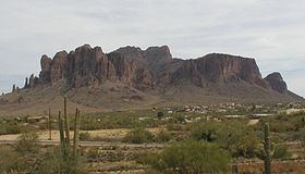
Superstition Mountain (Yavapai: Wi:kchsawa, O'odham: Gakoḍk) is located immediately east of the Phoenix metropolitan area in Arizona. It anchors the west end of the Superstition Wilderness. Although its precise origin is debated by geologists, many believe that the mountain was formed from volcanic activity as far back as 25 million years ago. The ash and basalt composed mountain was eroded by the elements to give it the unique form it has today, creating the prominent landmark and popular recreation destination in the region.
Contents
- Legend of the superstition mountains black cross butte s1 e6 history
- Map of Superstition Mountain Arizona 85118 USA
- Haunted canyon superstition mountains
- References
Map of Superstition Mountain, Arizona 85118, USA
The mountain, located near Apache Junction and Gold Canyon, Arizona, is easily accessible from U.S. Route 60 and State Route 88. It is a popular three season (fall, winter, spring) hiking area. Afternoon temperatures from June to September are usually in the range of 100 to 115 °F near the mountain. Day hikers often frequent the mountain during cooler months. The Lost Dutchman State Park is located on the western side of the mountain and includes hiking trails to notable formations such as the Praying Hands and the Flatiron. The Peralta Trail, on the southern side of the mountain, traverses Fremont Saddle and descends into the wilderness to the east of the mountain.