
Country United States FIPS code 30-72625 Elevation 842 m Population 851 (2013) Area code 406 | Time zone Mountain (MST) (UTC-7) GNIS feature ID 0791730 Zip code 59872 Local time Friday 6:27 PM | |
 | ||
Weather 14°C, Wind NW at 5 km/h, 49% Humidity Area 3.03 km² (2.719 km² Land / 31 ha Water) | ||
Superior is a town in and the county seat of Mineral County, Montana, United States. The population was 812 at the 2010 census. Superior was named after its founders' hometown of Superior, Wisconsin in 1869. The post office was established in 1871 after Mineral County became the site of one of the largest gold strikes that helped settle the West.
In the 1860s and 70s, several thousand miners converged on Cedar Creek to earn their fortunes. Long after that strike played out, mining remained a mainstay of the economy. Mining, along with the development of logging and United States Forest Service activities contribute to the area's interesting history.
Contents
- Map of Superior MT 59872 USA
- Geography and climate
- 2010 census
- 2000 census
- Television
- Notable people
- References
Map of Superior, MT 59872, USA
The town made history again in 1908, when the Superior Hotel received the first Bibles to be placed in hotel rooms by The Gideons. Today a plaque on Mullan Road W. marks the spot.
This small town offers a break from interstate travel and an introduction to area history in the Mineral County Museum. Display subjects explore local history and industry, including John Mullan and the Mullan Road.
Superior High School is the main public high school of the town.
Geography and climate
Superior is located at 47°11′36″N 114°53′25″W (47.193305, -114.890379), along Interstate 90 57 miles northwest of Missoula.
According to the United States Census Bureau, the town has a total area of 1.17 square miles (3.03 km2), of which, 1.05 square miles (2.72 km2) is land and 0.12 square miles (0.31 km2) is water.
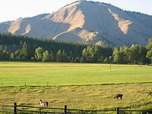
Superior's elevation is 2,744 feet (836 m) above sea level. Superior is surrounded by mountains, right in the middle of the Bitterroot Range. The Clark Fork flows through downtown, heading north towards St. Regis, Montana and ultimately emptying into Lake Pend Oreille near Cabinet, Idaho. The mountains to the west of Superior along the Montana/Idaho border receive a large amount of precipitation annually, mostly due to the amount of snow in the winter months. Nearby Lookout Pass Ski and Recreation Area receives 400 inches on average each winter. The snow pack melts throughout the spring and summer months, feeding the many mountain streams and creeks with water. All of the water eventually reaches the Clark Fork in the valley below, where Superior is located.
2010 census
As of the census of 2010, there were 812 people, 386 households, and 220 families residing in the town. The population density was 773.3 inhabitants per square mile (298.6/km2). There were 431 housing units at an average density of 410.5 per square mile (158.5/km2). The racial makeup of the town was 93.8% White, 0.7% African American, 1.2% Native American, 1.6% Asian, 0.1% from other races, and 2.5% from two or more races. Hispanic or Latino of any race were 2.3% of the population.
There were 386 households of which 20.2% had children under the age of 18 living with them, 43.0% were married couples living together, 9.6% had a female householder with no husband present, 4.4% had a male householder with no wife present, and 43.0% were non-families. 37.6% of all households were made up of individuals and 17.8% had someone living alone who was 65 years of age or older. The average household size was 2.05 and the average family size was 2.64.
The median age in the town was 52.1 years. 15.9% of residents were under the age of 18; 6.9% were between the ages of 18 and 24; 15.9% were from 25 to 44; 35.4% were from 45 to 64; and 25.9% were 65 years of age or older. The gender makeup of the town was 48.5% male and 51.5% female.
2000 census
As of the census of 2000, there were 893 people, 358 households, and 218 families residing in the town. The population density was 823.3 people per square mile (319.2/km²). There were 410 housing units at an average density of 378.0 per square mile (146.6/km²). The racial makeup of the town was 92.83% White, 0.11% African American, 2.91% Native American, 0.78% Asian, 0.11% from other races, and 3.25% from two or more races. Hispanic or Latino of any race were 1.90% of the population.
There were 358 households out of which 29.1% had children under the age of 18 living with them, 47.8% were married couples living together, 9.2% had a female householder with no husband present, and 39.1% were non-families. 33.8% of all households were made up of individuals and 12.8% had someone living alone who was 65 years of age or older. The average household size was 2.32 and the average family size was 2.93.
In the town, the population was spread out with 25.3% under the age of 18, 6.9% from 18 to 24, 26.2% from 25 to 44, 24.0% from 45 to 64, and 17.6% who were 65 years of age or older. The median age was 40 years. For every 100 females there were 99.8 males. For every 100 females age 18 and over, there were 99.1 males.
The median income for a household in the town was $25,333, and the median income for a family was $31,650. Males had a median income of $24,688 versus $18,750 for females. The per capita income for the town was $14,154. About 10.4% of families and 17.0% of the population were below the poverty line, including 23.0% of those under age 18 and 7.4% of those age 65 or over.
Television
KPAX Missoula, Montana
KECI Missoula, Montana