
Coat of arms Flag rural okrug 26 Area 57,804 km² | Rural localities 39 Founded 9 January 1930 | |
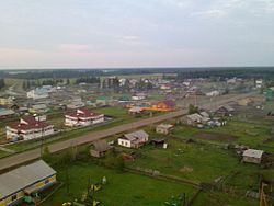 | ||
Suntarsky District (Russian: Сунта́рский улу́с; Yakut: Сунтаар улууһа, Suntaar uluuha, [suntaːɾ uluːha]) is an administrative and municipal district (raion, or ulus), one of the thirty-four in the Sakha Republic, Russia. It is located in the western central part of the republic and borders with Nyurbinsky District in the north and northeast, Verkhnevilyuysky District in the east, Olyokminsky District in the southeast, Lensky District in the southwest, and with Mirninsky District in the west. The area of the district is 57,800 square kilometers (22,300 sq mi). Its administrative center is the rural locality (a selo) of Suntar. Population: 25,140 (2010 Census); 25,485 (2002 Census); 26,035 (1989 Census). The population of Suntar accounts for 39.9% of the district's total population.
Contents
- Map of Suntarsky District Sakha Republic Russia
- Geography
- Climate
- History
- Demographics
- Economy
- Transportation
- Inhabited localities
- References
Map of Suntarsky District, Sakha Republic, Russia
Geography
The main river in the district is the Vilyuy.
Climate
Average January temperature ranges from −34 to −50 °C (−29 to −58 °F) and average July temperature ranges from +17 to +18 °C (63 to 64 °F). Annual precipitation is about 250–300 millimeters (9.8–11.8 in).
History
The district was established on January 9, 1930.
Demographics
As of the 1989 Census, the ethnic composition was as follows:
Economy
The economy of the district is mostly based on agriculture. There are deposits of gold, brown coal, gypsum, anhydrite, construction materials, and others minerals.
Transportation
The Vilyuy Highway runs through the district, connecting it with Yakutsk, Vilyuysk, and Mirny. There is an airport in Suntar.
Inhabited localities
Divisional source:
Population source:
*Administrative centers are shown in bold