
Population 1,877 2011 Census Sovereign state United Kingdom | ||
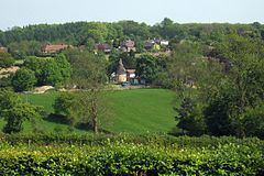 | ||
Sundridge and Ide Hill is a civil parish in the Sevenoaks District of Kent, England. It is located in the Darenth valley and lies between Sevenoaks and Westerham. The parish contains the villages of Sundridge and Ide Hill and the hamlet of Goathurst Common. It lies within the Kent Downs Area of Outstanding Natural Beauty and within London’s Metropolitan Green Belt. It is approximately 32 miles south of London.
Contents
Map of Sundridge with Ide Hill, UK
The parish, created in 1894, is one of the oldest in the country. Between the two villages is Emmetts Garden, a National Trust property.
"According to the 2011 census the total population of the parish was 1,877. Of that total, there were 917 males and 960 females living in the parish".
History
The history of the parish dates back over 1000 years to some of the earliest recorded times in the UK. Sundridge Church was known to have existed in 862, "probably as a wooden structure, and later was recorded in the Domesday Book”. The parish is quoted in the Domesday Book (1086) of having "27 villagers with 9 smallholders and 8 slaves". It was also under the lordship of the Archbishop of Canterbury during this time period, due to its location in Kent. Among the many historic buildings located in the parish lies Old Hall on Main Road, which dates all the way back to “1458, is thought to be the oldest original building” in the parish.
In the 19th century John Marius Wilson's Imperial Gazetteer of England and Wales described the parish as:
Sundridge, "a village and a parish in Sevenoaks district, Kent. The village stands 3¼ miles WSW of Sevenoaks r. station; has a post-office under Sevenoaks; and gives the title of Baron to the Duke of Argyle".
Population
The population of the parish has seen large changes since monitoring of the population began back in 1801. In 1801, they were 373 males and 342 females living in the parish. The population steadily grew over the 19th and 20th century where it peaked in 1960 with 1,035 males and 1,213 females living in the parish, a total population of 2,248. Since the 1960s, the total population has began to gradually decline and the latest population figures from the 2011 census show that the parish has a population of 1,877, a 16% decrease from the peak population in 1960.
Occupations
In 1881, the occupational structure for males in the parish was dominated by the Agricultural sector which was similar to many parishes across the country during this time period. Just under half of the 441 working men in the parish worked in the agriculture sector with a total of 183 in the sector which was no doubt the dominant industry at the time. The 2nd largest male occupation was those that worked in the General or Unspecified Commodities industry which was also closely linked to the Agriculture sector which suggests that the Agriculture industry was indirectly linked to over half of Male Occupations in 1881. The female occupational structure was of a stark contrast to the males in 1881. Women in the UK in the 19th century were prevented from working in certain occupations such as agriculture and substance services. Of the entire 403 working women, 226 women were listed as having unknown occupations which suggests they were either unemployed or only undertook smaller, unlisted jobs. Domestic Services or Offices was the largest listed female industry in the parish and 103 women worked in this industry.
The 2011 occupational structure in the parish between women and men is much more similar than that of the 1881 occupational structure. The total working men in the parish increased to 528 from the 441 in 1881, a slight increase obviously due to the population rise over the past two centuries. The agriculture industry which dominated the male occupational structure has completely diminished and no one in the parish, male or female works in the industry. The dominant industry for the males in the parish was those working in the skilled trades industry with 112 men working in the sector. Closely followed was those working in professional occupations with 101 men and those serving as managers, directors and senior officials in which 97 men were involved in this type of work. The total amount of female workers in the parish also increased from 403 to 459 from 1881 to 2011. The occupational structure for females in the parish saw drastic change from that of the 1881 structure. Women are now able to pursue the same careers as men so the occupational structure is very much similar to the male one. The top female occupation was those in professional occupations, 94 women worked in this industry which is similar to their male counterparts. The 2nd most employed industry was the 90 women working in the administrative and secretarial positions. The close proximity to London suggests why the parish has a significantly high percentage of female and male managers and directors living in the parish.
Church Of St Mary's
In the parish along Church Road lies the Church of St Mary’s which was constructed in 1865 by an architect who’s listed name is Cooke. The name of the church, along with many other Christian churches in the United Kingdom is dedicated to Saint Mary the Virgin. The church has a total seating capacity of 160. It is a Grade I listed building due to its “Excellent late medieval roofs; Very good medieval lychgate”. This listing makes it only one of the three Grade I listed buildings in the parish.
Transport
The M25 otherwise known as the London Orbital Motorway passes through the parish which gives residents direct access into Central and Greater London by car.
The nearest train station to the parish is Sevenoaks railway station which is around 3.5 miles east in the town of Sevenoaks. The station runs on the South Eastern Main Line which also provides easy access to London.