
Country United States Incorporated 1990 Elevation 400 m Zip code 37872 Local time Friday 6:49 AM | Settled 1810s Time zone Eastern (EST) (UTC-5) Area 9.8 km² Population 547 (2013) Area code 423 | |
 | ||
Weather 13°C, Wind W at 10 km/h, 88% Humidity | ||
How to say or pronounce usa cities sunbright tennessee
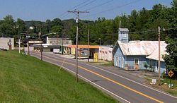
Sunbright is a city in Morgan County, Tennessee, United States. The population was 547 in 2014.
Contents
- How to say or pronounce usa cities sunbright tennessee
- Map of Sunbright TN 37872 USA
- History
- Geography
- Demographics
- References
Map of Sunbright, TN 37872, USA
History
The Sunbright area was first settled in the early 19th century. It was originally known as "Pine Top", but was renamed "Stapleton" after the Staples family set up the town's first post office in the mid-19th century. When the railroad was constructed through the area in 1879, the Stapleton depot was named "Sunbright," and the name was eventually applied to the entire town.
In 1916, an oil field was discovered in the hills immediately west of Sunbright, and the city thrived for several years as an oil shipping hub. An oil well was in operation within a year, and 15 wells were in operation in the Sunbright area by 1927.
Geography
Sunbright is located at 36°14′51″N 84°40′22″W (36.247369, -84.672692). The city is situated atop the Cumberland Plateau approximately 25 miles (40 km) west of the plateau's Walden Ridge escarpment. Sunbright is surrounded by low mountains and hills that comprise the fringe of the Cumberland Mountains.
White Oak Creek, which drains Sunbright, is part of the upper watershed of the Big South Fork of the Cumberland River. The Big South Fork's watershed meets the watershed of the Emory River atop Pilot Mountain, immediately south of Sunbright.
Sunbright is centered along U.S. Route 27, which connects the city to Wartburg and Harriman to the south and Huntsville, Tennessee and Lexington, Kentucky to the north. US-27 intersects Interstate 40 approximately 25 miles (40 km) south of Sunbright.
According to the United States Census Bureau, the city has a total area of 3.8 square miles (9.8 km2), all of it land.
Demographics
As of the census of 2000, there were 577 people, 229 households, and 158 families residing in the city. The population density was 151.8 people per square mile (58.6/km²). There were 264 housing units at an average density of 69.4 per square mile (26.8/km²). The racial makeup of the city was 98.44% White, 0.17% Native American, 0.87% from other races, and 0.52% from two or more races. Hispanic or Latino of any race were 0.87% of the population.
There were 229 households out of which 33.6% had children under the age of 18 living with them, 53.7% were married couples living together, 11.4% had a female householder with no husband present, and 30.6% were non-families. 25.3% of all households were made up of individuals and 10.5% had someone living alone who was 65 years of age or older. The average household size was 2.52 and the average family size was 3.06.
In the city, the population was spread out with 26.3% under the age of 18, 9.2% from 18 to 24, 28.1% from 25 to 44, 24.8% from 45 to 64, and 11.6% who were 65 years of age or older. The median age was 35 years. For every 100 females there were 93.0 males. For every 100 females age 18 and over, there were 85.6 males.
The median income for a household in the city was $27,763, and the median income for a family was $31,094. Males had a median income of $28,000 versus $16,944 for females. The per capita income for the city was $12,102. About 20.0% of families and 24.4% of the population were below the poverty line, including 31.1% of those under age 18 and 27.0% of those age 65 or over.