
Nearest city St. Louis, Missouri Area 4,000 m² | NRHP Reference # 84002689 Added to NRHP 17 February 1984 | |
 | ||
Address 4420 Ohio Ave, St. Louis, MO 63111, USA Similar Towosahgy State Historic S, Larson Site, Velda Mound, Millstone Bluff, Nacoochee Mound | ||
Sugarloaf mound
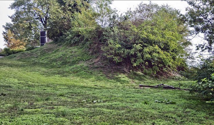
Sugarloaf Mound is the sole remaining Mississippian culture platform mound in St. Louis, Missouri, a city commonly referred to in its earlier years as "Mound City" for its approximately forty Native American earthen structures.
One of the city’s best-known earthen structures, "Big Mound" was razed in the mid-1800s following a sale of the land to the North Missouri Railroad. In preparation for the 1904 World's Fair, an additional sixteen mounds were destroyed. The mounds in Forest Park were mapped and excavated and had human remains associated with them. A group of mounds was near the St. Louis Art Museum and some were near the golf course. Today, about 80 mounds are preserved in the nearby Cahokia Mounds State Historic Site directly across the Mississippi River. Sugarloaf mound is only one of about 40 mounds that remain in St. Louis. The mounds were constructed by Native Americans that lived in the St. Louis area from about 600-1300 A.D, the same civilization that built the mounds at Cahokia. Sugarloaf mound is on the National Register of Historic Places.
The mound got its name in the 18th century when St. Louisans noticed the shape resembled the loaves that sugar was transported in. Although the mound has not been excavated, it is assumed that the mound was used for burials.
Sugarloaf Mound measures approximately 40 feet (12 m) in height, 100 feet (30 m) north/south and 75 feet (23 m) east/west. The mound overlooks the Mississippi River, where Interstate 55 meets South Broadway. It is now located entirely within the incorporated City of St. Louis, but used to be on the border between St. Louis and the formerly autonomous city of Carondelet. In 1809 the mound was used as a survey landmark when St. Louis was incorporated.
A residence was constructed abutting Sugarloaf Mound in the 20th century, and portions of the mound were also impacted by a quarry and the construction of Interstate 55. Although suppressed in some online municipal records, the Sugarloaf Mound house was standing and still bore a mailing address of 4420 Ohio Street as of March 2013.
It was purchased by the Osage Nation in 2009 with the stated intention of preservation. The Osage Nation does not claim a direct link to the construction of the mound, but claims a kindred heritage of mound building in the American Midwest. "Preservation" does not include the existing residence, but, by 2013, seems to point to an intention to restore Sugarloaf Mound to a condition similar to its configuration before the advent of Non-Native American architectural embellishments and razings.