
Criteria iii, iv Phone +1 618-346-5160 | Type Cultural Area 8.9 km² | |
 | ||
Governing body Illinois Historic Preservation Agency Official name Cahokia Mounds State Historic Site Address Collinsville, IL 62234, USA Similar Profiles | ||
Cahokia mounds state historic site
The Cahokia Mounds State Historic Site /kəˈhoʊkiə/ (11 MS 2) is the site of a pre-Columbian Native American city (c. 600–1400 CE) directly across the Mississippi River from modern St. Louis, Missouri. This historic park lies in southern Illinois between East St. Louis and Collinsville. The park covers 2,200 acres (890 ha), or about 3.5 square miles (9 km2), and contains about 80 mounds, but the ancient city was much larger. In its heyday, Cahokia covered about 6 square miles (16 km2) and included about 120 human-made earthen mounds in a wide range of sizes, shapes, and functions.
Contents
- Cahokia mounds state historic site
- Cahokia mounds state historic site in collinsville illinois
- Development
- Rise and peak 13th century
- Decline
- Notable features
- Monks Mound
- Urban landscape
- Mound 72
- Copper workshop
- Woodhenge
- Related mounds
- Cahokia Museum and Interpretive Center
- Designations
- References
Cahokia was the largest and most influential urban settlement of the Mississippian culture that developed advanced societies across much of what is now the central and southeastern United States, beginning more than 1000 years before European contact. Today, Cahokia Mounds is considered the largest and most complex archaeological site north of the great pre-Columbian cities in Mexico.
Cahokia Mounds is a National Historic Landmark and a designated site for state protection. It is also one of only 23 UNESCO World Heritage Sites within the United States. The largest prehistoric earthen construction in the Americas north of Mexico, the site is open to the public and administered by the Illinois Historic Preservation Agency and supported by the Cahokia Mounds Museum Society.
Cahokia mounds state historic site in collinsville illinois
Development
Although there is some evidence of occupation during the Late Archaic period (approximately 1200 BCE) in and around the site, Cahokia as it is now defined was settled around 600 CE during the Late Woodland period. Mound building at this location began with the Emergent Mississippian cultural period, about the 9th century CE. The inhabitants left no written records beyond symbols on pottery, shell, copper, wood and stone, but the elaborately planned community, woodhenge, mounds and burials reveal a complex and sophisticated society. The city's original name is unknown.
The Mounds were later named after the Cahokia tribe, a historic Illiniwek people living in the area when the first French explorers arrived in the 17th century. As this was centuries after Cahokia was abandoned by its original inhabitants, the Cahokia tribe was not necessarily descendants of the original Mississippian-era people. Most likely multiple indigenous ethnic groups settled in the Cahokia area. Though widely debated, some archaeologists connect Dhegihan Siouan-speaking tribes to Cahokia. They include the Osage, Kaw, Omaha, Ponca, and Quapaw. These peoples are generally believed to have migrated from the east of the Ohio Valley. Many Native American tribes migrated over the centuries in response to local conditions and intertribal warfare. Those living in territories at the time of the European encounter were often not the descendants of peoples who had lived there centuries before and built the mounds.
Historian Daniel Richter notes that the apex of the city occurred during the Medieval Warming Period. This period appears to have fostered an agricultural revolution in upper North America, as the three-fold crops of maize, beans (legumes) and gourds (squash) were developed and adapted or bred to the temperate climates of the north from their origins in Meso-America. Richter also notes that Cahokia's advanced development coincided with the development to the west of the Chaco Canyon society, which also produced large-scale works in an apparent socially stratified society. The decline of the city coincides with the little ice age, although by then the three-fold agriculture remained well-established throughout temperate North America.
Rise and peak (13th century)
Cahokia became the most important center for the peoples known today as Mississippians. Their settlements ranged across what is now the Midwest, Eastern, and Southeastern United States. Cahokia was located in a strategic position near the confluence of the Mississippi, Missouri and Illinois rivers. It maintained trade links with communities as far away as the Great Lakes to the north and the Gulf Coast to the south, trading in such exotic items as copper, Mill Creek chert, and whelk shells.
Mill Creek chert, most notably, was used in the production of hoes, a high demand tool for farmers around Cahokia and other Mississippian centers. Cahokia's control of the manufacture and distribution of these hand tools was an important economic activity that allowed the city to thrive. Mississippian culture pottery and stone tools in the Cahokian style were found at the Silvernale site near Red Wing, Minnesota, and materials and trade goods from Pennsylvania, the Gulf Coast and Lake Superior have been excavated at Cahokia.
At the high point of its development, Cahokia was the largest urban center north of the great Mesoamerican cities in Mexico and Central America. Although it was home to only about 1,000 people before c. 1050, its population grew rapidly after that date. According to a 2007 study in Quaternary Science Reviews, "Between AD 1050 and 1100, Cahokia’s population increased from between 1400 and 2800 people to between 10,200 and 15,300 people". an estimate that applies only to a 1.8 km2 high density central occupation area. Archaeologists estimate the city's population at between 6,000 and 40,000 at its peak, with more people living in outlying farming villages that supplied the main urban center. In the early 21st century, new residential areas were found to the west of Cahokia as a result of archeological excavations, increasing estimates of area population. If the highest population estimates are correct, Cahokia was larger than any subsequent city in the United States until the 1780s, when Philadelphia's population grew beyond 40,000.
One of the major problems that large centers like Cahokia faced was keeping a steady supply of food. A related problem was waste disposal for the dense population, and Cahokia became unhealthy from polluted waterways. Because it was such an unhealthy place to live, Snow believes that the town had to rely on social and political attractions to bring in a steady supply of new immigrants; otherwise the town's death rate would have caused it to be abandoned earlier.
Decline
The population of Cahokia began to decline during the thirteenth century, and the site was eventually abandoned around 1300. The area around it was not reoccupied by indigenous tribes. Scholars have proposed environmental factors, such as over-hunting, deforestation and flooding, as explanations.
Another possible cause is invasion by outside peoples, though the only evidence of warfare found so far is the wooden stockade and watchtowers that enclosed Cahokia's main ceremonial precinct. Due to the lack of other evidence for warfare, the palisade appears to have been more for ritual or formal separation than for military purposes. Diseases transmitted among the large, dense urban population are another possible cause of decline. Many theories since the late 20th century propose conquest-induced political collapse as the primary reason for Cahokia’s abandonment.
Together with these factors researchers found evidence in 2015 of major floods at Cahokia, so severe as to flood dwelling places. Analysis of sediment from beneath Horseshoe Lake has revealed that two major floods occurred in the period of settlement at Cahokia, in roughly 1100-1260 and 1340-1460.
Notable features
The original site contained 120 earthen mounds over an area of 6 square miles (16 km2), of which 80 remain today. To achieve that, thousands of workers over decades moved more than an "estimated 55 million cubic feet [1,600,000 m3] of earth in woven baskets to create this network of mounds and community plazas. Monks Mound, for example, covers 14 acres (5.7 ha), rises 100 ft (30 m), and was topped by a massive 5,000 sq ft (460 m2) building another 50 ft (15 m) high."
Monks Mound
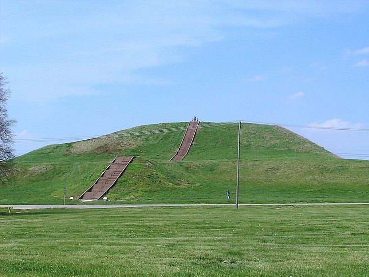
Monks Mound is the largest structure and central focus of the city: a massive platform mound with four terraces, 10 stories tall, and the largest man-made earthen mound north of Mexico. Facing south, it is 100 ft (30 m) high, 951 ft (290 m) long, 836 ft (255 m) wide and covers 13.8 acres (5.6 ha). It also contains about 814,000 cu yd (622,000 m3) of earth. The mound was built higher and wider over the course of several centuries through as many as ten separate construction episodes, as the mound was built taller and the terraces and apron were added.
Monks Mounds was named for the community of Trappist monks that resided there for a short time, after Euroamericans settled the area. Excavation on the top of Monks Mound has revealed evidence of a large building, likely a temple or the residence of the paramount chief, which would have been seen throughout the city. This building was about 105 ft (32 m) long and 48 feet (15 m) wide, and could have been as much as 50 ft (15 m) high. It was about 5,000 sq ft (460 m2).
A large flat plaza located adjacent to Monks Mound was a place where games and public rituals took place. The most popular was the game of chunkey. The game was played with young men rolling a pill-shaped chunky stone across the field. The men would throw spears where they thought the chunky stone would land. The game required a great deal of judgement and aim.
The east and northwest sides of Monks Mound were twice excavated in August 2007 during an attempt to avoid erosion due to slumping. These areas were repaired to preserve the mound.
Urban landscape
The Grand Plaza is a large open plaza that spreads out to the south of Monks Mound. Researchers originally thought the flat, open terrain in this area reflected Cahokia's location on the Mississippi's alluvial flood plain, but instead soil studies have shown that the landscape was originally undulating. In one of the earliest large-scale construction projects, the site had been expertly and deliberately leveled and filled by the city's inhabitants. It is part of the sophisticated engineering displayed throughout the site. The Grand Plaza covered roughly 50 acres (20 ha) and measured over 1,600 ft (490 m) in length by over 900 ft (270 m) in width. It was used for large ceremonies and gatherings, as well as for ritual games, such as chunkey. Along with the Grand Plaza to the south, three other very large plazas surround Monks Mound in the cardinal directions to the east, west, and north.
The high-status district of Cahokia was surrounded by a long palisade that was equipped with protective bastions. Where the palisade passed, it separated neighborhoods. Archaeologists found evidence of the stockade during excavation of the area and indications that it was rebuilt several times. Its bastions showed that it was mainly built for defensive purposes.
Beyond Monks Mound, as many as 120 more mounds stood at varying distances from the city center. To date, 109 mounds have been located, 68 of which are in the park area. The mounds are divided into several different types: platform, conical, ridge-top, etc. Each appeared to have had its own meaning and function. In general terms, the city center seems to have been laid out in a diamond-shaped pattern approximately 1 mi (1.6 km) from end to end, while the entire city is 5 mi (8.0 km) across from east to west.
Mound 72
During excavation of Mound 72, a ridge-top burial mound south of Monks Mound, archaeologists found the remains of a man in his 40s who was probably an important Cahokian ruler. The man was buried on a bed of more than 20,000 marine-shell disc beads arranged in the shape of a falcon, with the bird's head appearing beneath and beside the man's head, and its wings and tail beneath his arms and legs.
The falcon warrior or "birdman" is a common motif in Mississippian culture. This burial clearly had powerful iconographic significance. In addition, a cache of sophisticated, finely worked arrowheads in a variety of different styles and materials was found near the grave of this important man. Separated into four types, each from a different geographical region, the arrowheads demonstrated Cahokia's extensive trade links in North America.
Archeologists recovered more than 250 other skeletons from Mound 72. Scholars believe almost 62 percent of these were sacrificial victims, based on signs of ritual execution, method of burial, and other factors. The skeletons include:
The relationship of these burials to the central burial is unclear. It is unlikely that they were all deposited at the same time. Wood in several parts of the mound has been radiocarbon-dated to between 950 and 1000 CE.
Excavations have indicated that Mound 72 was not constructed as a single mound, but rather as a series of smaller mounds. These mounds were reshaped and covered over to give Mound 72 its final ridge-top shape.
Copper workshop
Excavations near Mound 34 from 2002 to 2010 revealed a copper workshop. This unique discovery had been found in the 1950s by archaeologist Greg Perino but lost for 60 years. It is the only known copper workshop to be found at a Mississippian site. The area contains the remains of three tree stumps thought to have been used to hold anvil stones. Analysis of copper found during excavations showed that it had been annealed, a technique involving repeatedly heating and cooling the metal as it is worked, as blacksmiths do with iron.
Artisans produced religious items, such as long-nosed god maskettes, ceremonial earrings with a symbolic shape, thought to have been used in fictive kinship rituals. Many of the stylistically related Mississippian copper plates, such as the Wulfing cache from southeastern Missouri, some of the Etowah plates from Georgia, and many of the Spiro plates from Oklahoma, are associated with the Greater Braden Style and are thought to have been made in Cahokia in the 13th century.
Woodhenge
Archaeologists discovered postholes during excavation of the site to the west of Monks Mound, revealing a timber circle. Noting that the placement of posts marked solstices and equinoxes, they referred to it as "an American Woodhenge", likening it to England's well-known circles at Woodhenge and Stonehenge.
Detailed analytical work supports the hypothesis that the placement of these posts was by design. The structure was rebuilt several times during the urban center's roughly 300-year history. Evidence of another timber circle was discovered near Mound 72, to the south of Monks Mound.
According to Chappell, "A beaker found in a pit near the winter solstice post bore a circle and cross symbol that for many Native Americans symbolizes the Earth and the four cardinal directions. Radiating lines probably symbolized the sun, as they have in countless other civilizations." The woodhenges were significant to the timing of the agricultural cycle.
A reconstructed Woodhenge was erected in 1985 on the site.
Related mounds
Until the 19th century a series of similar mounds existed in what is now the city of St. Louis, some 20 km (12 mi) to the south west of the Cahokia site. Most of these mounds were leveled throughout the construction of St. Louis, as their material was reused in construction projects.
The lone survivor of these mounds is Sugarloaf Mound, which is located on the west bank of the Mississippi. It marked the initial border between St. Louis and the once autonomous city of Carondelet.
Cahokia Museum and Interpretive Center
The Cahokia Museum and Interpretive Center, which receives up to a million visitors a year, was designed by AAIC Inc. The building, which opened in 1989, received the Thomas H. Madigan Award, the St. Louis Construction News & Reviews Readers Choice Award, the Merit Award from the Metal Construction Association, and the Outstanding Achievement Award from the Brick Manufacturer Association.
Designations
Cahokia Mounds was first protected by the State of Illinois in 1923 when its legislature authorized purchase of a state park. Later designation as a state historic site offered additional protection, but the site came under significant threat from the federal highway building program in the 1950s. The highway program reduced the site's integrity; on the other hand, it increased funding for emergency archeological investigations. These investigations became intensive, and today continue, and have led to the present understanding of the significance of the site. The site was designated a National Historic Landmark on July 19, 1964, and listed on the National Register of Historic Places on October 15, 1966.
In 1982 UNESCO (the United Nations Educational, Scientific and Cultural Organization) designated the site a World Heritage Site. This is the only such site in Illinois and among only twenty-three World Heritage Sites in the United States. United States Representative Evelyn M. Bowles wrote about the Cahokia Mounds site:
"Through the years my friends and I made occasional Sunday afternoon trips to the Mounds. When I became the State Senator, it afforded me the opportunity to secure funds for the acquisition of additional acreage in which there are smaller Mounds. Many of these have contained additional artifacts." The designation has helped protect the property and attract funds to conduct research on this significant civilization.