
Population 0 | ||
 | ||
Similar Rotokare Scenic Reserve, Pukekura Park, New Plymouth Coastal, Tūpare, Paritutu Rock | ||
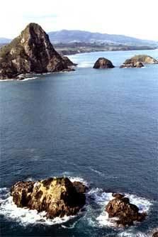
The Sugar Loaf Islands (often Sugarloaf Islands) (Māori: Ngā Motu, "the islands") are a collection of five small uninhabited islands and several sea stacks near Port Taranaki, Taranaki, New Zealand. The largest island, Moturoa Island, covers approximately 1.4 hectares (3.5 acres). Motumahanga is the island furthest from shore, at approximately 1,500 metres (1,600 yards) or 1.5 kilometres (0.93 miles).
Contents
Map of Sugar Loaf Islands, 4310, New Zealand
The Sugar Loaf Islands Marine Protected Area (SLIMPA) was established in 1991 to protect the area from oil exploration. This strengthened the protection that had been in place since the formation of a marine park in 1986.
The island group was named in 1770 by James Cook.
Islands
The Sugar Loaf Islands can be divided into inner and outer island groups.
The inner islands comprise Mataora (Round Rock), Pararaki (Seagull Rock) and Motuotamatea (Snapper Rock). Mataora connects to the mainland at low tides, as does Motuotamatea on very low spring tides. Pararaki is separated from Mataora by a 20 meter wide channel.
The outer islands comprise Motumahanga (Saddleback Island) and Moturoa.
Several small rock outcrops are included in the island group. Waikaranga (Seal Rocks), and Tokatapu are several hundred meters offshore. Close to Moturoa lie Whareumu (Lion Rock),a vegetated stack and two barren rocks, and Tokomapuna (Barrett Reef).
Marine protected area
In 1986, an area encompassing the Sugar Loaf Islands was protected as a marine park. Concern over oil exploration led to strengthening of the protection, through the enacting of the Sugar Loaf Islands Marine Park Act in 1991. An area of 752.5 hectares (1,859 acres), including 5.3 hectares (13 acres) of land, encompassing the islands and surrounding seabed and ocean spanning from Port Taranaki in the north to Herekawa Stream in the south, was protected from commercial, recreational fishing and mining. The act deemed Moturoa Island, Motumahanga, Waikaranga, and Whareumu as sanctuary areas (requiring a permit for entry), with the remaining area a conservation park. Reef heron, Little blue penguin, New Zealand Fur Seal, and Orca are monitored species. The islands are on migration routes for oceanic birds and cetaceans (whales and dolphins).
In 2008, the 1404 ha Tapuae Marine Reserve was established adjacent to the Sugar Loaf Island Marine Protected Area (SLIMPA).
Geology
The Sugar Loaf Islands, along with onshore pinnacles such as Paritutu (153 m or 502 ft), represent the oldest volcanic activity on the Taranaki peninsula. Dating between 1.7 and 1.74 million years of age, the islands are believed to be the remains of a ring fracture or feeders to eroded volcanic vents, and are composed of a porphyritic hornblende andesite. Volcanic activity in Taranaki subsequently shifted to Kaitake (580,000 years ago), then migrated southeast to Pouakai (230,000 years ago) and the current centre of activity, Taranaki (last erupted in 1755).
The Sugar Loaf Islands are the type locality of taranakite, a phosphate mineral that forms from the reaction of bird guano with the aluminous rocks comprising the islands. This was the first new mineral species to be discovered in New Zealand.