
Mexico Ind. 1821 INEGI Code 070 Elevation 15 m | Yucatán Est. 1824 Area 256.8 km² | |
 | ||
Time zone Central Standard Time (UTC-6) | ||
Sucilá Municipality (Yucatec Maya: "zacate (grass) water") is one of the 106 municipalities in the Mexican state of Yucatán containing (256.76 km2) of land and is located roughly 150 kilometres (93 mi) northeast of the city of Mérida.
Contents
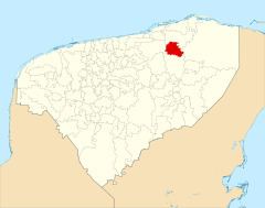
- Map of SucilC3A1 YucatC3A1n Mexico
- History
- Governance
- Communities
- Local festivals
- Tourist attractions
- References
Map of Sucil%C3%A1, Yucat%C3%A1n, Mexico
History
There is no accurate data on when the town was founded, but before the conquest, it was part of the chieftainship of Cupules. At colonization, Sucilá became part of the encomienda system and though an encomienda was established by the seventeenth century, no names were discovered before the encomendera Josefa Chacón y Salazar, who served in 1745.
Yucatán declared its independence from the Spanish Crown in 1821, and in 1825 the area was assigned to the Tizimín Municipality. In 1837, it was assigned to the Espita Municipality. As with other areas of the state, Sucilá was depopulated during the Caste War of Yucatán. In 1988, the area was confirmed as its own municipality.
Governance
The municipal president is elected for a three-year term. The town council has four councilpersons, who serve as Secretary and councilors of public services, public security, urban development and ecology.
Communities
The head of the municipality is Sucilá, Yucatán. The municipality has 63 populated places besides the seat including La Hacienda Xmabalam, San Antonio, San Pedro II, San Miguelito, San Román, Santa Rosa, Santa Teresa, Tierra Blanca, Xmihuan, and Yohches. The significant populations are shown below:
Local festivals
Every year from 2 to 10 September there is a festival in honor of the Nativity of the Virgin Mary.