
City Stuttgart Area 6.815 km² Administrative region Stuttgart | District Stuttgart Founded 10th Century Dialling code 0711 | |
 | ||
Stuttgart-Nord is an inner city district in the north of Stuttgart.
Contents
Map of Nord, Stuttgart, Germany
Geography
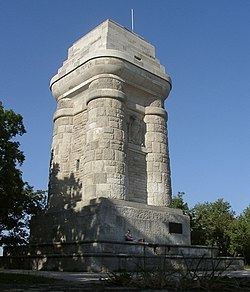
Stuttgart-Nord extends from the Doggenburg to the highest point, the Gähkopf (409 m above sea level) to the Bismarckturm, on the Killesberg and the Pragsattel to Rosenstein Park and the Pragfriedhof. The Pragsattel located at the lowest point of a ridge from Killesberg to Burgholzhof.
One finds in Stuttgart-Nord numerous good residential areas and viewpoints on the Stuttgart city center. Noteworthy streets are: Am Bismarckturm, Am Gähkopf, Caesar Flaischlen Street, Eduard-Pfeiffer-Straße, Feuerbacher Heide, Lenzhalde, Robert-Bosch-Straße and Schottstraße.
History
When Stuttgart was divided into districts in 1956, Stuttgart-North was created. The western boundary of this new district extended from the Doggenburg to Weißenhof and Killesberg. When the districts were reorganized January 1, 2001, Stuttgart-North was split itself into 11 subdistricts.