
Postal code 851 11 Area 90 ha Island group Dodecanese | Time zone EET (UTC+2) Vehicle registration ΚΧ, ΡΟ, ΡΚ Area code 22460 Regional unit Kalymnos | |
 | ||
Similar Farmakonisi, Imia/Kardak, Prasonisi, Therasia, Nea Kameni | ||
Kastellorizo
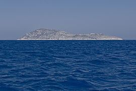
Strongyli Megistis (Greek: Στρογγυλή Μεγίστης), also called plainly Strongyli or Ypsili, is a Greek islet which lies in the eastern Mediterranean Sea, about five nautical miles south-east of the island of Kastellorizo. The island is about 1.5 kilometres (0.9 miles) long, and up to 700 metres (2,300 ft) wide. It covers an area of about 0.9 square kilometres (0.3 sq mi). It is rather flat and covered with macchia. The islet has no permanent residents.
Contents
Map of Strongyli Megistis, Megisti 851 11, Greece
Strongyli is the easternmost Greek territory. Administratively it is part of the Municipality of Megisti. According to the 2011 census the island is deserted. It has a lighthouse, which has the characteristic of being the easternmost building in Greece. The Turkish name for the island is Çam Adası (English: Pine island).