
 | ||
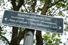
Strathkelvin Railway Path is rail trail following the route of several dismantled railway lines extending from Gartcosh to Strathblane.
Contents
Map of Strathkelvin Railway Path, Milton of Campsie, Glasgow G66 8BG, UK
History
The northern section follows the route of the Campsie Branch of the Edinburgh and Glasgow Railway which was extended as the Blane Valley Railway line and closed in 1951 (although some parts of the line were still used for freight into the '60s). The southern section follows a branch of the Monkland and Kirkintilloch Railway. Starting in Kirkintilloch it runs south and currently terminates at the northern tip of Gartcosh; just before the original railway junction would have split east to Bedlay Colliery and south to Glenboig.
Future Plans
It has been announced by Sustrans that the path will become part of the National Cycle Network and called route 755. In the future it is planned that the path will be extended to the north further following the route of the dismantled railway to incorporate part of the West Highland Way towards Drymen where it will link to National Cycle Network no. 754 (Forth & Clyde Canal) and National Cycle Network no. 7. To the south there are plans to continue the path to Drumpellier Country Park and then the Monkland Canal where it will link to National Cycle Network no. 75 in Coatbridge.