
Carries 64 Clearance below 23 metres (75 ft) Opened 7 July 1989 Longest span 130 m | Crosses Storseisund Design Cantilever bridge Toll until 1999 Total length 260 m Location Eide Body of water Storseisundet | |
 | ||
Similar Hardanger Bridge, Kvernes Stave Church, Geirangerfjord, Eshima Ohashi Bridge, Trift Bridge | ||
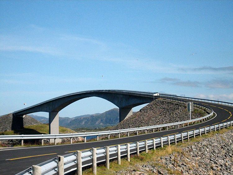
Storseisundet bridge
The Storseisundet Bridge (Norwegian: Storseisundbrua) is the longest of the eight bridges that make up the Atlanterhavsveien ("The Atlantic Road"), the road connection from the mainland Romsdal peninsula to the island of Averøya in Møre og Romsdal county, Norway.
Contents
- Storseisundet bridge
- Atlantic bridge storseisundet bridge atlantic highway norway tour 2015
- References
The bridge sits on the border between Eide Municipality and Averøy Municipality and passes through an archipelago as it links mainland Norway with the island of Averoy. It is one of the country’s official national tourist routes. The bridge was described as "The road to nowhere" by the Daily Mail in 2011.
Storseisundet Bridge is a cantilever bridge that is 260 metres (850 ft) long and with a maximum clearance to the sea of 23 metres (75 ft). It was opened on 7 July 1989, and it was a toll road until June 1999.
Over the six years that it took to construct, workers struggled with the region's wild weather and were interrupted by twelve hurricanes. One hundred and twenty-two million Norwegian krone were spent completing the project, seventy-five percent of which came from public grants. The rest of the funding was recovered with toll fees. The bridge was originally projected to recoup its investment in 15 years, but was completely paid for in ten years.